 Updating intensity-duration-frequency (IDF) curves used in drainage design gets plenty of attention, especially as it relates to climate change shifts. But is the focus misguided when it comes to urban flood risks?
A review of design rainfall patterns derived from Toronto-area IDF curves suggests more efforts should be placed on rainfall pattern (hyetograph) review instead - urban catchment risks may in fact be overlooked and underestimated when watershed scale storms are applied over flashy, high risk city drainage systems.
First, lets agree that all runoff simulation models are wrong but some are useful. Also, all synthetic design rainfall patterns are fictional, but can be quite useful depending on how they are applied - scale is an important consideration in this. Many watershed-scale storms are applied across smaller urban tributaries that respond to short duration rainfall intensities - the small tributaries feed in along the length of the large watershed or lie across headwater areas.
Below, Toronto IDF curves are compared with several watershed storm rainfall intensities extracted from design storm patterns used in Toronto-area watersheds (Don River, Rouge River, Humber River, Etobicoke Creek, Mimico Creek, Duffins Creek, Carruthers Creek, Highland Creek and Petticoat Creek).
 |
| Comparison of wateshed design storms and Toronto (City gauge) IDF characteristics - design rainfall intensities for the 6 hour , 12 hour and 24 hour "AES" storm and 12 hour "SCS" storms underestimate the IDF values for short durations that are critical for flashy urban drainage catchments that may be at risk of overland or local riverine flooding. |
To illustrate just how dramatically rainfall intensities are underestimated, look at the 24 Hour AES storm used for Carruthers Creek hydrology simulations. The 1 hour rainfall intensity in that "100-year" storm is actually a less than a 2-year return period rainfall intensity based on the IDF data.
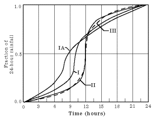 |
| SCS Type II curve high high rainfall over peak short durations (does not flatline). |
In the Toronto area, most urban drainage capacity issues and damages are associated with the small, local catchments and systems as opposed to the large river systems. This reflects great efforts and results in mitigating riverine flood risks following Hurricane Hazel. Quantitative analysis shows that basement flooding is concentrated on 'table land', as opposed to along flood-vulnerable valley systems. Accordingly, extreme rainfall characteristics that govern table-land flooding must be given adequate attention. Many watershed-scale design storms that may be appropriate for assessing river flood risks do not adequately characterize the short-duration, high intensity rainfall intensities documented in today's IDF data.
***
On the positive side, municipalities responsible for assessing and remediating urban flood risks often use design hyetographs that reflect the short duration high intensity behaviour of IDF data. Many municipalities use "Chicago storm" rainfall patterns (Keifer & Chu, 1957) which preserve the IDF intensities for those short durations that are critical in urban flood risk management.
The SCS Type II storm can also be applied in a manner that preserves the high rainfall intensity in the original cumulative fraction of rainfall curve. The US Department of Agriculture has a spreadsheet that can be used to provide rainfall fractions at 1/10th of an hour, or 6 minute, intervals:
http://www.wcc.nrcs.usda.gov/ftpref/wntsc/H&H/rainDist/SCSrainfallDistTimeTransformations.xlsx
Some caution: even when high intensities are preserved, some design rainfall patterns may not be appropriate in different hydrologic settings according to some agencies. The Ontario Ministry of Transportation (MTO) notes the following applicability when selecting synthetic storms:

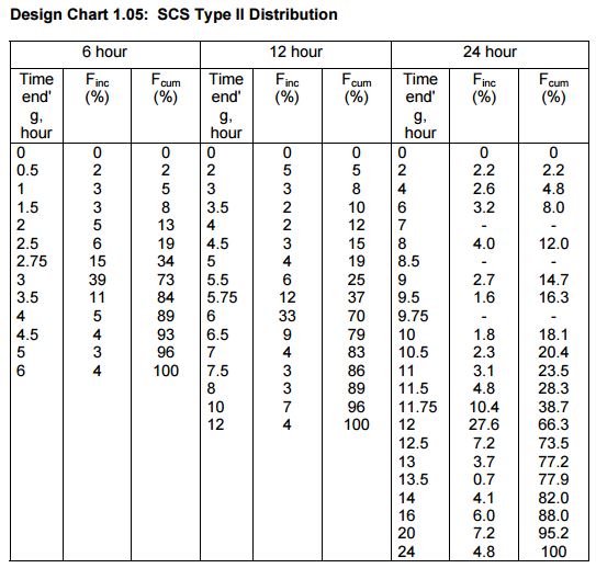 According to MTO, some watershed design storms may not be appropriate for rural land uses areas with less than 20% impervious area. When they are used, MTO provides a design chart in Part 4 of the Drainage Management Manual that shows the peak intensity increments. For example, in the SCS Type II 6 hour storm 39% of the rain falls in the peak 15 minutes from 2.75-3.0 hours. In the 12 hour storm, 33% of the event rainfall occurs in the peak 15 minutes from 5.75-6.0 hours. And lastly, for the 24 hour storm, 27.6% of rainfall occurs from 11.75-12.0 hours. Some "SCS" watershed storms in TRCA's jurisdiction flatline over 30 minutes to 2 hours which does not meet the MTO peak 15 minute characteristics, for rural land uses.
TRCA does incorporate short duration design storms in some watersheds, including the 1-hour AES storm in the Dunbarton Creek and Pine Creek watersheds and the 4-hour Chicago storm for Krosno Creek. Details are in the TRCA criteria document (Table 3-1: TRCA Stormwater Quantity (Flood) Control Criteria). The longer duration TRCA watershed storms should be applied with caution on small urban catchments where 100 year return period conditions could govern local regional storm flood conditions, and where IDF data may not be reflected in short duration rainfall rates.