The presentation below summarizes the research and is entitled "Disentangling Impacts of Climate & Land Use Change on Quantity & Quality of River Flows in Southern Ontario" - the authors, Trevor Dickinson and Ramesh Rudra from the University of Guelph clearly see the need to clarify drivers for flow changes and to avoid the common media mistake of associating all extreme hydrologic conditions with climate change and omitting changes that may lower risks (like spring flooding in some watersheds).
Disentangling Impacts of Climate & Land Use Change on Quantity & Quality of River Flows in Southern Ontario Trevor Dickinson Ramesh Rudra University of Guelph from Robert Muir
Research indicates:
1) Monthly and Annual Precipitation has remained unchanged (see slide 7)
2) Temperatures have risen 'mostly in the winter' (see slide 13 - 14), meaning summer maximum temperatures that are typically associated with extreme rainfall have not increased, or have decreased
3) Extreme daily maximum temperatures have decreased (slide 14)
4) Increased winter temperatures mean more steady winter runoff, more infiltration and "Decreased Snowmelt Floods" (see slides 24 - 31)
5) Urbanization increases runoff coefficients (slide 36-37) and:
" So … in Ontario urban watersheds: - urban development has augmented the winter and spring climate change impacts; and - summer flow volumes have increased dramatically, in volume and frequency, these impacts being completely due to urban development."
The big take away is that urbanization is a key driver for summer river flows in Southern Ontario, but climate change is not - this is supported by trends in the Engineering Climate Datasets (version 2.3) that show twice as many statistically significant decreasing Southern Ontario trends as increasing ones.
This analysis is consistent with review by others showing change in minimum temperatures but no change in summer maximum temperatures. For example, the Ontario Centre for Climate Impacts and Adaptation Resources reviewed climate change trends for several stations - for Ottawa airport, between 1939 and 2014, the average winter minimum is up by 2.5 degrees Celcius and average winter mean is up 2.2 degrees. But the summer maximum is flat - no change. While the summer mean temperature is up by 0.5 degrees, this is due to increases in minimum temperatures, which were up by 1.1 degrees. These graphs from the Centre show the difference in winter temperatures changes and summer temperatures changes:
 |
| Winter temperatures have increased with climate change - Ottawa, 1939-2016 |
 |
| Summer maximum temperatures (middle chart) have NOT increased with climate change - Ottawa, 1939-2016. Changes in mean temperature are driven by changes in minimum temperatures. |
The Ontario Centre for Climate Impacts and Adaptation Resources reviewed climate change trends for Hamilton as well. The following charts show the same relative temperatures changes as Ottawa:
 |
| Hamilton winter temperature has increased the most due to climate change. |
 |
| Hamilton summer temperatures have increased at only a fraction of the winter increase. |
Urbanization has increased significantly in Southern Ontario since the mid 1960's as shown in this post - this includes Hamilton growth:

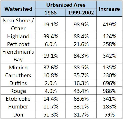
In the Toronto area, where the University of Guelph assessed changes in runoff and linked these to urbanization as opposed to climate change, growth has also been significant since the mid 1960's. The following table shows changes in Toronto-area watersheds where urbanization increased from 59% to 986% over a perido of about 35 years. Compared to theoretical temperature-induced water vapour changes changes of a few percentage, if any at all, urbanization clearly explains higher runoff stress and flood risk while climate change explains none of the risks.