Showing posts with label IBC. Show all posts

NRC National Guidelines on Flood Control Cost-Benefit Analysis Share Extensive Insurance Industry Loss Data Across Canada Define Flood Control Benefits

The National Research Council of Canada (NRC) has released the National Guidelines on Undertaking a Comprehensive Analysis of Benefits, Costs and Uncertainties of Storm Drainage and Flood Control Infrastructure in a Changing Climate.

The full guidelines are available here to download: https://nrc-publications.canada.ca/eng/view/object/?id=27058e87-e928-4151-8946-b9e08b44d8f7

These guidelines delve into many topics to support comprehensive benefit cost analysis. A previous post explored historical extreme rainfall trends related to flood damages (see post: https://www.cityfloodmap.com/2022/02/nrc-national-guidelines-on-flood.html). This post shares insurance industry loss data presented in the guidelines. Such data support the comprehensive assessment of direct and indirect flood losses that represent potential benefits of new and upgraded flood control infrastructure investments.

The NRC Guidelines identify two approaches for assessing flood damages for projects of various scale and detail including:

i) a bottom-up approach based on property-scale losses, and

ii) a top-down approach based on scalable national or regional insurance loss data.

Previously unavailable data was shared by several organizations including Munich Re, the Insurance Bureau of Canada, and CatIQ to support the analyses in the guidelines. Thank you!

CatIQ Property-Scale Flood Losses in Canada (Bottom-up Analysis)

Catastrophe Indices and Quantification Inc. (CatIQ) is a Toronto-based subsidiary of Zurich-based PERILS A.G. that delivers detailed analytical and meteorological information on Canadian natural and man-made catastrophes. Established in 2014, CatIQ and is supported by the majority of the Canadian insurance and reinsurance industry, allowing it to provide the most reliable source of catastrophe loss information in Canada. Data are available through CatIQ’s online subscription-based platform that includes comprehensive insured loss and exposure data used by the insurance industry and other stakeholders - we used this database to analyze regional and national flood and related water losses across Canada.

Records of flood and water loss and loss expenses analyzed were from January 2008 to January 2019 while records of sewer back-up/water losses analyzed were available from April 2013 to January 2019. 

As noted in the NRC Guidelines "Nationally, the average loss, representing closed claims is approximately $22,300 based on well over 70,000 claims – this average value is for 55 events. Due to many smaller events in the database, the median loss is lower than the average at $16,300". The following chart shows the distribution of losses across these 55 events (see Appendix D | Direct & Indirect Long Time Horizon Damages, Figure 8):

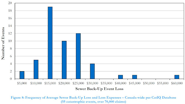
Given that CatIQ defines events and compiles loss data for those events with over $25M in losses, some small events with smaller losses. A review of CatIQ indicated that events with a higher number of claims, corresponding to more extreme and widespread events, reported higher average claims. 

CatIQ data shows regional differences in sewer-back losses as reported in the NRC Guidelines (Appendix D | Direct & Indirect Long Time Horizon Damages, Table 14):

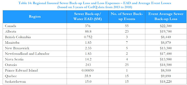
Intact Financial has recently noted that the often-cited average cost of $43,000 represents an upper limit for certain flood events (Intact Financial, 2019) - that makes sense for an extreme event, as reported in the NRC Guidelines:

"...an extreme event average claim approaching $40,000 could be appropriate. Specifically, the June 2013 Alberta flood event characterized by extensive riverine flooding had an average claim of over $37,000 for nearly 8000 sewer back-up/water claims."

The one instance of an event with average claims of up to $60,000 per policy represented only a handful of claims. Note that some have mistakenly cited the above $43,000 value as the average cost of a flooded basement across Canada, which is not supported by available data. It could be more reflective of overall losses in some regions, including both insured and uninsured losses. 

How can this data be used to assess benefits in cost benefit analysis? The NRC Guidelines presents a case study evaluating local sewer improvement alternatives using CatIQ data to assess benefits.  See Appendix I | Case Studies | Case Study 3 -  EXISTING STORM SEWER SYSTEM DAMAGE REDUCTION.

For another example, refer to the NRC Guidelines authors 2020 WEAO fall webinar paper that illustrates how regional sewer-back-up losses can be used to derive EAD values for project areas. That example applies where the number of flooded basements is available through detailed, local modelling. See post with paper:   https://www.cityfloodmap.com/2021/12/national-guideline-development-for.html.

More examples? Infrastructure Canada's Disaster Mitigation Adaptation Fund (DMAF) requires an assessment of Return on Investment (ROI) for candidate projects, specifying a minimum ratio of benefits to costs of 2:1. Local sewer back-up flood damages may be used to better define the potential benefits of infrastructure investments that reduce losses, following the approach in the WEAO fall webinar paper above. Depending on the level of service for a flood damage reduction project, a significant portion of expected damages many be avoided, and counted as benefits in a DMAF ROI calculation.

Munich Re Insured and Overall Losses (Top-Down Analysis)


Munich Re
gratefully drilled down into previously-available North American loss data presented in its NatCatSERVICE and provided historical Canadian insured losses for hydrological and meteorological events, and estimated uninsured losses.

The NRC Guidelines present the following figure showing these historical losses for meteorological and hydrological ‘event families’ including meteorological events (tropical storms, extra-tropical storms, convective storms and local windstorms) and hydrological events (flood and mass movement)  (see Appendix D | Direct & Indirect Long Time Horizon Damages, Figure 5): 

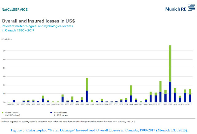
Munich Re data were then analyzed to derive return-period and Expected Annual Damages (EAD) across Canada. The analysis revealed 'average' 2-year losses of $426M and rare 100-year losses of $2.29B. The EAD was $697M for insured losses (the blue bars in the figure above), showing that expected losses that factor in occasional extreme losses is higher than the average.

Obviously such flood losses are significant and need to be managed. Expected annual insured losses of $695M represent about 0.4% of the Canadian GDP of $1.6T. 

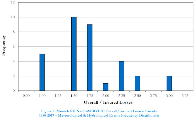
Overall losses that include uninsured losses are higher and are represented by the green bars in the chart above. Munich Re estimates this as described in NatCatSERVICE documentation and considers insurance market penetration and reported disaster assistance payouts. The following chart shows the relation between overall and insured losses (ratio of green to blue bars above)(see (see Appendix D | Direct & Indirect Long Time Horizon Damages, Figure 7):


The overall losses in an individual year could be 3 times the insured losses. On average from 1983 to 2017, overall losses were 1.94 times insured losses. Why is there variability? Well, different types of hazards in Canada have different levels of insurance coverage. Sewer back-up has a relatively high degree of coverage and in years dominated by severe urban flooding events (e.g., Toronto and GTA in 2005) there would be relatively lower uninsured losses. In contrast, riverine flood insurance is was previously not available for residential properties in Canada until about 2015, and may not be available for high risk non-residential properties in floodplains - so in 2013, Calgary riverine flooding would not have been insurable (although many companies may still have granted claims in that instance as a 'goodwill measure' as noted by KPMG in 2014).  

How can Munich RE loss data be used to assess benefits of adaptation to flooding and inform funding policies? The overall losses can guide us as to how much we should invest to reduce these damages. 

The NRC Guidelines include case studies that apply Munich RE loss data including (see Appendix I | Case Studies):

i) CASE STUDY 1 – NATIONAL-LEVEL POLICY DEVELOPMENT, and

ii) CASE STUDY 2 – MUNICIPALITY-LEVEL PROJECT PLANNING

Case Study 1 conclusions note broadly how insurance loss information may be used: "This case study demonstrates that high-level policy decisions may be sufficiently informed through available information sources for future benefits (using insurance industry data to guide the estimation of avoided future losses), and the setting of target economic performance (using a benefit-cost ratio approach or some other relevant measure of return on investment) to establish, in this case, appropriate funding levels for allocation."

In the Case Study 1 example analysis, based on a i) Munich RE overall (insured and uninsured) EAD value of $1.347B (2017 dollars) for water damage (hydrological and meteorological events), and ii) CatIQ EAD of $819 million (2018 dollars) for insured flood loss and loss expense, a representative EAD of $1.0B was considered. This values was used to estimate an annual funding allocation noting:

 "Accordingly, based on the parameters assumed in this analysis relating to the estimation of benefits, time value of money and acceptable benefit-cost ratio (return on investment), a national flood protection policy could allocate about $2.8 billion annually (in 2020 dollars) for a 10-year period on projects that would achieve the technical performance objectives sought."

Case Study 2 conclusions note how insurance loss data was applied at a municipal and project-scale assessment of damages and benefits: "This case study demonstrates the downscaling of broad-scale insurance industry loss data to more granular levels for application to a municipality-level program and further down to the level of a collection of projects within the municipality. This “top down” approach to estimating future benefits (avoided losses) negates the need for highly detailed “bottom-up” methods for urban drainage system damage and benefit estimation when such approaches might be impractical or require excessive efforts relative to the accuracy they might produce. That is, estimation of urban drainage system damages on a bottom-up (property scale) basis, considering minor and major storm system risk, wastewater system risk, system interactions, and property-scale grading and construction factors has not been shown to be feasible or correlated to reported damages."

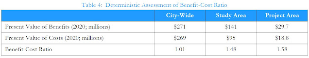
Munich RE loss data was used in Case Study 2, based on the City of Markham, Ontario to determine the following expected annual damages (and potential benefits of infrastructure investments):

• EAD for City-Wide Level Assessment: $13.2 million

• EAD for Assessment of Study Area: $5.1 million

• EAD for Assessment of Project Area: $0.8 million

The scaling of national Munich RE loss data and EAD considered proportion of population in Case Study 2. Regional loss data from IBC or CatIQ, excluding uninsured losses, could similarly be scaled. A review of proportion of GDP, as part of DMAF ROI assessments in Markham, indicated a similar proportion to population. The NRC Guidelines illustrate how several economic, demographic, built-form and infrastructure parameters are closely correlated across regions of Canada, and are related to regional expected losses. This is the basis of top-down loss scaling considered where bottom-up property scale analysis is impractical.

The following tables summarize the benefits (based on scaled Munich RE losses), costs (see a future post on costing data), and achieved benefit-cost ratios at a municipal, broad study area, and at a sub-project scale.


Investing in Canada's Future: The Cost of Climate Adaptation - does infrastructure spending recommended in a new report for by IBC for FCM make sense?

Investing in Canada's Future: The Cost of Climate Adaptation
Investing in Canada's Future: The Cost of Climate Adaptation,
Report by IBC and FCM, September 2019 
A new report by the Insurance Bureau of Canada attempts to answer an important question: How much should we invest in adaptation measures to prevent effects of climate change?

The report summary "Investing in Canada's Future: The Cost of Climate Adaptation" (link) suggests the following:

"The analysis determined that an average annual investment in municipal infrastructure and local adaptation measures of $5.3 billion is needed to adapt to climate change. In national terms, this represents an annual expenditure of 0.26% of GDP."

"Flood, erosion and permafrost melt are associated with the highest cost to GDP ratios at 1.25, 0.12 and 0.37, respectively. These climate risks require the greatest investment in adaptation."

The infographic summary (link) suggests that " the benefits of investing in community adaptation and resilience outweigh the cost of such investments by a ratio of 6 to 1".

Let's review this in terms of mitigation of flood damages.

The annual expected insured losses from hydrologic and meteorologic events in Canada is $0.7B based on Munich Re data.  Overall losses are $1.27B considering Munich Re ratios.  Over 100 years that some infrastructure lasts, that is $127B in losses, some that can be effectively mitigated or deferred.  If there is a 6:1 benefit:cost ratio to adaptation efforts, then spending $127B/6 = $21.2B would be the cost of the adaptation program to 'break even' (let's assume that is the capital cost and not operation and maintenance).

The IBC FCM study suggests spending of $5.3B per year - a lot more than the 'break even' number -and notes "What is needed now is an ambitious and long-term investment plan for disaster mitigation and adaptation charted along a time frame of not year-to-year, but for the next twenty years or longer."

Let's look at the numbers.

If we invest $5.3B per year for 20 years, that is $106B. So that is a benefit:cost ratio of $127B:$106B or 1:2:1.  If we invest $5.3B a year for 25 years, the cost exceeds the benefits.  That investment is a lot higher than what we would expect if we achieved a 6:1 benefit:cost ratio, spending only $21.2B.

If we consider that losses cannot be completely deferred with adaptation (as it is rarely 100% effective, and there may always be events that exceed design capacity leaving residual damages, and overall losses cannot be completely deferred), the potential benefits over 100 years may be only $70B, assuming all insured losses can be mitigated.  That means spending $5.3B a year for 20 years, or $106B will cost more than the benefits.

This should be carefully reviewed.  The value of all municipal storm and wastewater and bridge infrastructure in Canada is $418 B (see my 2018 CWWA presentation here). So investing $106B, or 25% of the value of all that infrastructure value is a lot.  Some municipality flood mitigation programs has been estimated at only 6% of asset value.

Setting investment levels appropriately is important and further analysis is needed.  It would also be worthwhile distinguishing between the cost to address today's infrastructure capacity and land use planning risks and future risks.  Much of Canada's current $0.7B in damages is due to existing level of service deficiencies and not future climate effects.

***

In a previous study Green Analytics acknowledged the difference between damages due to economic growth and those due to future climate effects.  It would be worth looking at effects of future growth on damages and consider those in assessing infrastructure investment requirements.


Are Six 100 Year Storms Across the GTA Rare Over a 14 Year Period When Considering Probabilities of Observing Extremes at over 150 Rain Gauges?

Roll a 100-sided die once. That is what looking
for a 100 Year storm at a single rain gauge
in a single year is like.
A motion at the City of Toronto notes the following regarding extreme rainfall in the GTA: "According to the Insurance Bureau of Canada, the Greater Toronto Area has had six “100 Year Storms” since 2005". See Mike Layton motion here: https://www.toronto.ca/legdocs/mmis/2019/mm/bgrd/backgroundfile-131063.pdf

CBC has reported on this: link

While we are all concerned about flooding, the question on large storm frequency is "So What?". Or more specifically, from a statistical, mathematical, logical point of view, is more than five 100 Year storms over a 14 year period (2005 to 2018) rare and unexpected, or does this have a high probability of occurring? As we know the Insurance Bureau of Canada does not always rely on proper statistics to support statements on extreme weather, confusing theoretical shifts in probabilities of extreme events with real data (see IBC Telling the Weather Story where IBC ignores Environment and Climate Change Canada's Engineering Climate Datasets).

Let's do some math to see if over five 100 Year storms is rare or not.

First, consider that a 100 Year storm has a probability of occurring of 1/100 = 1 percent per year.

***

Second, count up the number of rain gauges that have been proliferating across the GTA to support inflow in infiltration studies for wastewater studies and to support operational needs. Here are some counts with various sources:

i) City of Toronto (https://www.toronto.ca/city-government/data-research-maps/open-data/open-data-catalogue/water/#09dee024-b840-174f-7270-29c1a1773d14) - 46 rain gauges

ii) Region of York (https://www.york.ca/wps/wcm/connect/yorkpublic/b22ae2f3-5140-48f2-869e-a803d2552893/2017+Inflow+and+Infiltration+Reduction+Strategy+Annual+Report.pdf?MOD=AJPERES) - 71 rain gauges

iii) Peel Region (https://www.peelregion.ca/council/agendas/pdf/ipac-20110811/4b.pdf) - 6 rain gauges (correction July 25, 2019 - Peel has 28 rain gauges ... probabilities in this blog post will go up a bit)

iv) Halton Region (https://www.peelregion.ca/budget/2018/pdf/conservation-halton.pdf) - 14 rain gauges

v) Toronto and Region Conservation Authority (http://199.103.56.152/xcreports/Precipitation/precipitationOverview.aspx) - 14 rain gauges

Total number of gauges = 151. A good first estimate - certainly there are more. (correction July 25, 2019 - as Peel has 28 rain gauges the total is 173 stations)

***

Third, assuming each rain gauge observes rainfall events independently year to year, what is the chance of getting at least one 100 Year event at a single gauge in 14 years?

Probability = 1 - (1-1/100)^14 = 13.1% chance of a 100 Year storm storm at a single gauge. That seems pretty big.

The number of 'trials' or samples equivalent to 14 rolls of a 100-sided die, meaning 14 independent observations or 'samples' from the statistical population of events.

It is reasonable to assume that a single rain gauge can record a 100 Year event but not surrounding gauges? Yes indeed. The August 2018 storm in Toronto only exceeded 100 Year rainfall totals at one gauge. So it is reasonable for smaller, spatially isolated rainfall events that do occur.

***

Fourth, assuming all rain gauges observe rain independently what is the chance of getting more than one 100 Year events across all 151 gauge in 14 years?

The number of trials/samples/observations = 151  x 14 = 2114

Probability = 1 - (1-1/100)^(2114) = over 99.9% chance of at least one 100 year storm at 151 independent gauges. That is almost a certainty.

(Additional comment: we know that storms exceeding 100 Year volumes can cover large areas such that observations are adjacent gauges are not completely independent, especially if they are spatially very close - so this fourth scenario is considered an upper bound on sensitivity analysis considering gauge independence - below, another bound is evaluated assuming less independence).

What about more than five 100 Year storms over 14 years? We have to then consider combinations of events (we do not care which of the 2144 samples has the events) and approach this by subtracting the probability of 1, 2, 3, and 4 events. This summarizes the approach (thanks so much FP!):


The probability of 5 or more 100 Year events is again over 99.9% (see cell F22), showing that when there are many, many trials, the probability of a multiple rare event is very high.

***

Fifth, assuming large storms cluster across several gauges and they do not operate independently from each other for extreme events, and that say they observe 100 Year storms in groups of 5, what is the chance of getting one 100 Year event across 151/5 = 30.2 rain gauge clusters in 14 years?

The number of trials/samples/observations = (151 x 14) / 5 = 2114 / 5 = 422.8

Probability = 1 - (1-1/100)^(422.8) = over 98.5% chance of at least one 100 year storm at 30 independent gauge clusters.  Near certainty. Not rare at all!

Let's consider over five 100 Year storms again. A keen reader has shown that the probability is 41.6% for this, as shown in cell L22 in the spreadsheet image above. Again, pretty high chance of getting 5 or more events when gauges do not observe extremes independently, but rather in clusters.

For more on this analysis, and the probability of 5 or more occurrences in 423 observations the probabilities considered in deriving the probability are as follows:
  • 4 occurrences in 423 observations (P = 0.195038119)
  • 3 occurrences in 423 observations (P = 0.183893083)
  • 2 occurrences in 423 observations (P = 0.1297298)
  • 1 occurrences in 423 observations (P = 0.060868484)
  • 0 occurrences in 423 observations (P = 0.014245815)
  • Sum = 0.583775302
So P[ X ≥ 5; 423] = 1 - 0.583775302 = 0.416224698, or 41.6% noted above. This is the common approach for deriving the probability of a scenario, i.e., by subtracting the probability of the event not occurring from 1.0 (the probability of all events). In this case the sum of the probability of zero to 4 observations occurring is the probability of the scenario of interest (5 occurrences or more) not occurring. If you are interested in testing other scenarios and assumptions for size of rain gauge clusters, use this helpful web site (also used to check the calculations in the spreadsheet shared above): https://stattrek.com/online-calculator/binomial.aspx. Below are checks of the probability analysis:

Probability of 5 or more 100 Year Storms at Independent Rain Gauges (151 gauges x 14 years = 2114 'trials')
Probability of 5 or more 100 Year Storms at Clusters of Rain Gauges With Dependent  Observations (30.2 gauge clusters x 14 years = 422.8, say 423, 'trials')

There are more rain gauges in Durham Region and other Conservation Authorities in the GTA which means there may be more than 30 clusters to observe extreme weather in, meaning an even higher probability of observing extreme events.

So about 423 rolls of a 100-sided die may result in more than five occurrences of a single number with a relatively high probability. If the clusters are bigger, the probability is a bit less, but as we have seen, sometimes only one gauge 'sees' the 100 Year extreme rain. If gauges observe events in clusters of 10, which is an extreme end of the range as we have examples of storms affecting only one gauge (August 2018 in Toronto), there is still a probability for 5 events of over 5% (see below):

Probability of 5 or more 100 Year Storms at Large Clusters of Rain Gauges With Dependent  Observations (15.1 gauge clusters x 14 years = 211.4, say 211, 'trials')
Past flood events in Toronto reveal that between 1 and 12 rain gauges observe 100 Year rainfall depth, as shown in this Toronto Water presentation: https://www.slideshare.net/glennmcgillivray/iclr-friday-forum-reducing-flood-risk-in-toronto-february-2016
It shows:

  • May 12, 2000 - 1 rain gauge over 100 Year (see slide 9)
  • August 19, 2005 - 12 rain gauges over 100 Year (see slide 11)
  • July 8, 2013 - 6 rain gauges over 100 Year (see slide 19)
The August 7, 2018 flood in Toronto was due to only one Toronto rain gauge in the Open Data dataset exceeding 100 Year volumes. Therefore, assuming a cluster size of 5 dependent rain gauges within independent clusters that observe extreme events seems quite reasonable.


Conclusion - is it not rare to get more than five 100 Year rainfall observations at over 151 GTA gauges, over 14 years. The chances range from near certainty (over 99.9%) for independent events at each rain gauge to relatively high probability (over 40%) if gauges are independent clusters of 5 or more.

***

So what else does that tell us? There is a tendency to exercise an 'availability bias' in the words of Daniel Kahneman, and ignore statistics when making quick observations about extreme events. A description of this and other "Thinking Fast" heuristic biases surrounding flooding and extreme weather is in this paper.

Most media reports seldom "do math" and echo sources without question many times - that was the finding of the CBC Ombudsman on this topic of more frequent or severe extreme rainfall recently - see Ombudsman ruling.

Its one thing for a reporter to echo IBC statements on extreme weather for a news story, but Toronto should be careful in taking on a court case with limited data - it would be great to see any IBC statistics or analysis (unlike in the Telling the Weather Story communications). Toronto should also be aware that its flood problems are due mainly to its own design standards in the original size municipalities dating back before the 1980's. Spatial analysis shows that is where the risks are and where the flood reports are being made to the City of Toronto - see slide 36 in this review of flood risk factors which clearly do not include more extreme weather - partially separated systems have the highest risk and Toronto has allowed development to occur without mitigating risks in the past (hence the famous Scarborough Golf court case decision against municipalities for gaps in their stormwater management practices (Scarborough Golf Country Club Ltd v City of Scarborough et al)). Same thing on other GTA cities - see slide 7 in this presentation to the National Research Council's national workshop on urban flooding February 2018 for flood vulnerabilities in the City of Markham - see where Mississauga flood calls occur in this previous post (more than half of flood calls are in pre-1980 areas designed with limited resiliency for extreme weather).

So there has always been flooding:


And the most extreme rainfall intensities in Toronto over short durations happened in the 1960's:


And now extreme rainfall statistics from Environment and Climate Change Canada show decreasing short duration intensities since 1990 in and around Toronto:


.. as shown in a previous post. These 5 minute 100 Year intensities have dropped between 4.0 % and 8.1% between 1990 and 2016-2017 depending on the location.

Such decreases in short duration intensities are happening across southern Ontario as well, based on the newest Engineering Climate Datasets as shown here. Toronto should be careful in preparing for a legal challenge and any claims on flood causes.

As noted in my recent Financial Post OpEd, making a big deal about irrelevant risk facts distracts us from addressing the root cause of flood problems. The City of Toronto should try to not get distracted. And Councilor Mike Layton is probably in the running for a Milli Vanilli "Blame it on the Rain" award this year :)

***

Terence Corcoran covers this all very well in today's column, referencing analysis on this blog.

Note: probabilities for 5 or more events corrected/updated April 1, 2019. Thanks to keen readers for helping define the probabilities of combination events and for the nostalgic references to University of Toronto's Professor Emeritus Dr. Barry Adams' CIV340 course notes that outline the analysis approach.

***

What are the probabilities considering the updated number of stations (i.e., more in Peel), meaning a total of 173 stations? That is, 2422 trials if stations are independent and 484 trials if stations are clustered in clusters of 5.

For 5 or more 100-year storms in 14 years, the probability is 99.9% - 53.2% for independent and clustered gauges, respectively.

For 6 or more storms the probability is 99.9% - 35.6% for independent and clustered gauges, respectively.

Storm Warts, The Floods Awaken, A New Hope for Cost-Effective Investment in Flood Management Infrastructure, #NWWC2018 Robert Muir

Storm Warts
Storm Warts are the blemishes in our infrastructure system
capacity that reduce resiliency and contribute to flood losses.


My presentation "Storm Warts, The Floods Awaken" at The National Conference of the Canadian Water and Wastewater Association, Montréal, Canada, on November 5, 2018 will have a light show, light saber show that is.

Click below for the print version of the slides (unfortunately without all the fancy animation and sounds):


The presentation identifies benefit cost analysis as a "New Hope" for guiding infrastructure investment, so that they deliver a high return on investment by focusing on the blemishes in storm and waterwater collection systems, aka, "Storm Warts".

The presentation reviews the statement in the media, put forth by the insurance industry and affiliated researchers, that water damages are increasing and are a key driver for increasing catastrophic losses. The presentation shares data that suggests floods have not "awakened", and are in fact becoming a smaller percentage of total catastrophic losses, as explored in a recent post.

The presentation also reviews case studies of benefit cost and economic analysis related to grey and green infrastructure, including natural infrastructure (green infrastructure, low impact development measures including wetlands and other features). This includes case studies from the recent Insurance Bureau of Canada report reviewed in another recent post. It is suggested that cost benefit studies require certain elements to be robust, reliable, and evidence-based, and that some case studies are lacking in these core requirements, representing "number stretching and concept massaging" as suggested in the Financial Post.

A comparison of return on investment, benefit cost ratios, for Markham's complete flood control program is made, including a group of low-cost, no-regrets best practices (i.e., policies and programs such as sanitary downspout disconnection, and backwater value and sump pump incentives), and city-wide grey infrastructure capital works resulting from a decade of master plans and Municipal Class EA studies.. The ROI of green infrastructure is also explored as part of a city-wide assessment, including an evaluation of potential flood mitigation benefits, as well as erosion mitigation and water quality improvements.

The need for comprehensive engineering analysis is suggested, showing that case studies that relied only on "meta-analysis", or high level estimation techniques, may not be able to provide reliable, meaningful ROI estimates sufficient to guide public infrastructure spending. Wetland, natural infrastructure benefit-cost ratio's are shown to be highly variable and potentially unreliable, as reviewed in an earlier post that incorporates some of the Storm Warts presentation (i.e., Pelly's Lake, Manitoba) and reviews other sources on natural infrastructure flood reduction potential and constraints.


Financial Post Identifies Gaps in Insurance Industry Statements on Extreme Rain Causes, Flood Losses Trends, and Effective Mitigation Strategies

Terence Corcoran's article today covers a lot of the science and engineering that cityfloodmap.com has been exploring and promoting over the past few years. It is great to see many of our findings reflected in the mainstream media now. Wow!

Terence Corcoran is a National Post columnist and one of Canada's leading business writers and editors and he has been writing on the insurance industry, climate change and flooding for a couple decades. In his article today he explores the topics of:

1. Catasrophic loss trends, including flooding and the effects of GDP growth on trends as well as the influence of different data sets - we have explored that extensively in a previous post suggesting loss trends are not increasing as dramatically as the media suggests.

2. Green infrastructure implementation costs - we showed that those are prohibitive as in a previous post looking at Ontario-wide implementation city-by-city, and then again when looking at Ontario-wide lifecycle cost in another post.

3. Green infrastructure can make flooding worse - that is due to infiltration into already stressed wastewater systems as noted by the US Transportation Research Board, WEAO, and Ontario and US cities and local experts, as noted in a previous post.

4. Green infrastructure has questionable cost efficiencies as we see in a Metrolinx 'green' parking lot that is actually benefiting from a 'grey' traditional engineered stormwater detention tank- we have further shown that traditional grey engineered infrastructure has a better return on investment than green infrastructure as assessed in a detailed Class EA study and through a city-wide technology review benefit/cost analysis summarized in this post.

5. Green infrastructure and natural infrastructure does not reduce flood damages - contrary to what is promoted by the insurance industry like in the recent IBC report - it does not reduce flood damages according to the Ontario Society of Professional Engineers, and cannot cost-effectively reduce US river flood damages as described in this post.

6. Storms are not more frequent or intense due to climate change, and the insurance industry has made up "Insurance Fact" statements that has been rejected by insurance companies as reliable advertising - this was explored in a previous post and in our paper in the Journal of Water Management Modeling called "Evidence Based Policy Gaps in Water Resources: Thinking Fast and Slow on Floods and Flow"; https://www.chijournal.org/C449


Thank you Terence Corcoran for helping to shed light on these topics!

Catastrophic Losses in Canada - Have Flood Damages Increased Significantly Or Have Changing Data Sources Affected Trends?

Disaster Losses Are Up
Catastrophic loss trends have been reported regularly in Canada, often in relation to flood damages. These have often linked to climate change effects as well as other factors that may include aging infrastructure (not a significant factor in our mind), or urbanization and intensification (the true overriding factor in many urban centres). This post looks at how trends have changed in relation to changes in data sources.

GDP Adjusted Losses are Down
A blog post by the Institute for Catastrophic Loss Reduction (ICLR) discusses loss trend reporting by the Insurance Bureau of Canada. ICLR discusses but dismisses the calls for adjusting losses for growth, which is commonplace in Munich RE NatCatSERVICE analysis and reporting, and which is promoted by may others (this includes my paper in the Journal of Water Management Modelling which evaluated losses adjusted for net written premiums, and Roger Pielke Jr.'s work, such as reported here in Five Thirty Eight - see charts to the right - that also calls for evaluating trends considering GDP growth).

The ICLR notes "Normalizing disaster loss data to include such factors as growth in population, economic activity and building stock is not a simple undertaking. Further, there are many problems with using simple measures like GDP or insurance premium growth as a normalizer. For these and other reasons, I don’t want to go ‘there’ at this point ...".

So ICLR is content to us the following chart that does not include GDP adjustments:

Catastrophic Losses Flood Damages Canada
Losses in Canada Unadjusted for GDP Growth - 1983-2007 Data per IBC Survey, 2008- Data per CatIQ.

The ICLR notes a change in the data source for the above graph: "Bureau data begins at 1983. From that year to 2007, IBC uses data it collected itself through various company surveys conducted immediately after significant natural disaster events. It also uses various data from Property Claim Services (PCS), Swiss Re, Munich Re and Deloitte. After 2007, the Bureau only uses data from Catastrophe Indices and Quantification Inc. (CatIQ)."

How does the change in data affect reported losses? We can look at how the increase in losses has been reported, for example by the ICLR in 2016:

Catastrophic Loss Trends in Canada. Effects of change in data source on reported losses pre 2008.
Below the ICLR chart, the timing of the change in data is shown. This indicates that the change in reported annual losses from $400M average up to 2008 to $1B average after corresponds to the change in data source in 2008.

More recently the Intact Centre on Climate Adaptation (ICCA) has reported trends in losses on TVO's The Agenda as shown in the chart below:

Intact Centre on Climate Adaptation cites changes in insurable claims on TVO (chart shown), with ICLR's noted change in data sources added below (IBC data up to 2007 and CatIQ data from 2008 onward).

Again, the change in data is added below the ICCA chart. The lower losses of $200-500M up to 2008 and higher losses typically over $1B from 2009 onward correspond to this change in data source.

Adjusting for data sources or for GDP does not really change priorities for flood risk and catastrophic loss reduction. Better characterization of the GDP-adjusted trend can give us insight into the effectiveness of past mitigation efforts, more-resilient design standards that are common in modern practice. Without such GDP adjustment, one would think that everything is built as disaster-prone as it was in the past. Also, understanding the cause of the trend in losses will help focus adaptation or mitigation efforts in the proper place - if increases are explained by GDP growth as opposed to changes in extreme weather (shown to not be a factor) efforts will be placed on adaptation infrastructure built to old, less-resilient design standards as opposed to mitigation (e.g., GHG reduction).

A more wordy comment has been added to the ICLR blog post.

***

A paper Trend Analysis of Normalized Insured Damage from Natural Disasters, published in:
Climatic Change, 113 (2), 2012, pp. 215-237, by Fabian Barthel and Eric Neumayer, Department of Geography and Environment and The Grantham Research Institute on Climate Change and the Environment, London School of Economics and Political Science explores "Normalized" / GDP adjusted damages, exploring trends for different types of events.

As noted in their abstract:

"As the world becomes wealthier over time, inflation-adjusted insured damages from natural disasters go up as well. This article analyzes whether there is still a significant upward trend once insured natural disaster loss has been normalized. By scaling up loss from past disasters, normalization adjusts for the fact that a hazard event of equal strength will typically cause more damage nowadays than in past years because of wealth accumulation over time. A trend analysis of normalized insured damage from natural disasters is not only of interest to the insurance industry, but can potentially be useful for attempts at detecting whether there has been an increase in the frequency and/or intensity of natural hazards, whether caused by natural climate variability or anthropogenic climate change."

The following charts from the paper show an increase in deflated (non-normalized) damage losses over time, and virtually no change in normalized losses.

Global deflated insured losses from natural disasters
Global normalised insured losses from all disasters
Similarly, the following charts illustrate normalized trends for convective storm events (4165 disasters) showing a decrease, all storms including winter and other storms but excluding tropical cyclones (4369 disasters) showing a decrease, and for tropical cyclones (874 disasters) showing an increase.

Global normalized insured losses from convective events
Global normalized insured losses from all storm events except tropical cyclones


Global normalized insured losses from tropical cyclones


***

The Government of Canada has reported that the majority of loss increases have been due to growth (more exposed people, assets and wealth), and that climate change 'may' be having an effect - this contrast many media and insurance industry comments. The true driver of increased losses was reiterated in the just-released Canada in a Changing Climate: National Issues Report (see post: https://www.cityfloodmap.com/2021/06/national-issues-report-identifies.html). Canadian loses have been normalized for growth and show a moderate increase over time - the report notes that earlier data may be incomplete, which would affect the normalized trend as well (more complete older data could decrease the trend).


TVO Articles on Climate Change, Extreme Rainfall and Urban Flooding Omit Basic Fact Checking and Ignore Fundamental Engineering Principles

I have posted comments on three TVO Articles on the topic of climate change, extreme weather, urban flooding and resiliency of Ontario Cities. Readers of this blog will be familiar with the content. It gets a bit repetitive from article to article, only because the data gaps are the same old ones we always see on these topics.  BONUS: a recent TVO broadcast is reviewed at the end of this post.

1) How climate change is making storms more intense, Published on Apr 21, 2017 by Tim Alamenciak

https://tvo.org/article/current-affairs/climate-watch/-how-climate-change-is-making-storms-more-intense

My Comments:
This is absolutely incorrect. Environment and Climate Change Canada (ECCC) published in Atmosphere-Ocean in 2014 that there is "no detectable trend signal" in the Engineering Climate Datasets related to short-duration rainfall that causes urban flooding:


Windsor has the lowest level of service for floodplain protection (100 year storm) while other regions have Hurricane Hazel (over 500 year storm) - so Windsor / Essex region will flood a lot more that other places. Also Windsor has been effectively tightening up their sanitary sewers to prevent spills to the river (reduced combined sewer overflows (CSOs)) which means more stays in the sewers and can back-up basements in extreme weather. Its a tough trade-off when environmental protection (keeping sewage out of the river) means more sewage in basements.

This is a recent summary of ECCC data as well as studies my Ontario universities and major engineering consultants saying decreases in extreme rainfall in Ontario. In fact there are twice as many statistically significant decreasing trends as increasing ones in southern Ontario (per the version 2.3 Engineering Climate Datasets - links to ECCC data files are all provided on the slides:


This presentation to the Ontario Waterworks Association and Water Environment Association of Ontario's Joint Climate Change Committee does extensive myth-busting related to extreme rainfall and flooding and explore the true drivers to increased flood events (spoiler-alert: its engineering hydrology and hydraulics, not meteorology). It also shows how the Clausius-Clapeyron relationship (theory relating temperature to extreme rainfall) has been disproved by research at MIT, Columbia and the University of Western. Unfortunately, there are lot of opinions and high level statements that are made without data. This is a pervasive problem in the media. When fact checking does occur, Advertising Standards Canada, the CBC Ombudsman and Canadian Underwriters have all agreed that there is no change to extreme rainfall. Here are some examples of that:

More data / facts / details:

Windsor decreasing extreme rainfall trends (Engineering Climate Datasets version 2.3 Station ID 6139525) - decreasing for ALL storm durations, and statistically significant decreases for durations of 10 minutes, 2 hours, 6 hours and 12 hours:


CBC Ombudsman confirms with ECCC, and disputes insurance industry statements that we have more storms (see letter to me):

http://www.cityfloodmap.com/2015/10/bogus-statements-on-storms-in-cbcnewsca.html

That was in response to this story that had no fact-checking:


And which had this correction made based on ECCC and real data: "However, Environment Canada says it has recently looked at the trends in heavy rainfall events and there were "no significant changes" in the Windsor region between 1953 and 2012." Canadian Underwriter editors dispute insurance industry statement on more frequent / severe storms after fact-checking with ECCC:


"Associate Editor’s Note: In the 2012 report Telling the Weather Story, commissioned to the Institute for Catastrophic Loss Reduction by the Insurance Bureau of Canada, Professor Gordon McBean writes: “Weather events that used to happen once every 40 years are now happening once every six years in some regions in the country.” A footnote cites “Environment Canada: Intensity-Duration-Frequency Tables and Graphs.” However, a spokesperson for Environment and Climate Change Canada told Canadian Underwriter that ECCC’s studies “have not shown evidence to support” this statement."

We can explain most increased flooding by hydrological changes over the past 100 years (same rain a before but more runoff than before as urban areas have expanded drastically across GTA watersheds over the past 60 years):

http://www.cityfloodmap.com/2016/08/urbanization-and-runoff-explain.html

... and specifically here is are the changes in hydrology in southern Ontario cities including the Windsor area:


We can also explain increased flooding with hydraulics related to municipal drainage design (tanks to hold back water and protect beaches can back up into basements like in my Toronto "Area 32" engineering flood study report), and related to overland flow in 'lost rivers' that statistically explain the highest concentrations of reported basement flooding:


Basically, hydrologic stresses have increases (more runoff) and conveyance capacity has decreased (reduced CSO relief, tanks to protect beaches, blocked overland flow paths in old 'lost rivers'). Underpinned/excavated basements are now lower than before, closer to the crown of the sewer pipes in the street and more prone to sewage back-ups than before, with no change in rainfall extremes due to climate change.

Robert J. Muir, M.A.Sc., P.Eng.

Toronto


2) How climate change is already costing you money, Published on Nov 01, 2017 by Patrick Metzger

https://tvo.org/article/current-affairs/climate-watch/how-climate-change-is-already-costing-you-money

My Comments:

There are many false statements in this article and a lack of basic science, statistics or critical engineering considerations. I am a licensed Professional Engineer with extensive experience in extreme weather statistics and municipal infrastructure planning and design (26 years) - this article is like 100's of others, skimming the surface and missing the critical data and conclusions, reinforcing stale pundit talking points in the climate-change-echo-chamber. Please see below for what is wrong with the article.

Firstly, the article conflates climate and weather which have different temporal scales. Climate includes rainfall and precipitation over seasons, years and decades while weather related to flooding in urban areas involves rainfall over minutes and hours. So the cited increase in precipitation is irrelevant to urban flooding and insurance since precipitation trends over months and years do not govern the performance of infrastructure systems (storm sewers, sanitary sewers, drainage channels and overland flow paths) - that infrastructure is governed by extreme rainfall rates over minutes and hours. It is an undeniable engineering fact. And these short duration rainfall intensities are 'flat' across Canada according to Environment and Climate Change Canada, as published in Atmosphere-Ocean in 2014 - in fact ECCC stated that some regions have decreasing trends including the St Lawrence basin in Quebec and the Maritimes.

My own fact checking of the Engineering Climate Datasets (version 2.3 on the ECCC ftp site) shows twice as many statistically significant decreases in southern Ontario as increases, and for the critical shortest durations, no statistically significant increases at all. Here is a review of the typical insurance industry statements and the real data:


Over the past two weeks I have correspondence from 3 scientists at ECCC stating that the annual precipitation statistic (climate) is irrelevant to urban flooding and the short duration rainfall (extreme weather) is what we should be looking at - across Canada the relevant data shows 'no detectable trend signal'. TVO should check the background of those providing information for these articles to see if the academic and practical experience aligned with the technical topic being discussed.

It is too easy to just try and may headlines and exercise 'availability bias', 'anchoring bias' and other problem-solving short cuts with discussing extreme weather and flooding. It is more responsible to look at real data and fact-check articles because there is important public policy on climate adaptation and mitigation that relies on the proper characterization of the problems that we are solving. Blaming flooding on rainfall trends misdirects resources to mitigation when it should be focused on adaptation to yesterday's extremes (due to intrinsic design limitations in 50-100 year old infrastructure and land use planning). Chief economists at major banks have repeated IBC statements on extreme weather shifts with no fact checking whatsoever - the Sun, the Star, CBC and individual insurance companies have repeated it too without checking. They have been fact checking with ECCC recently though and the consensus is that there is no shift in extreme rainfall and IBC mixed up a theoretical future shift (of an arbitrary 'bell curve' no less) and had reported it extensively as a past observation by ECCC. ECCC has denied that their data shows any increase in severe weather with climate change.

Some examples of ECCC refuting insurance industry claims:

Ombudsman confirms with ECCC, and disputes insurance industry statements that we have more storms (see letter to me):


That was in response to this story that had no fact-checking:

http://www.cbc.ca/news/canada/windsor/more-than-half-of-homeowners-insurance-claims-stem-from-water-damage-broker-says-1.3291111

And which had this correction made based on ECCC and real data: "However, Environment Canada says it has recently looked at the trends in heavy rainfall events and there were "no significant changes" in the Windsor region between 1953 and 2012."

Canadian Underwriter editors dispute insurance industry statement on more frequent / severe storms after fact-checking with ECCC:


"Associate Editor’s Note: In the 2012 report Telling the Weather Story, commissioned to the Institute for Catastrophic Loss Reduction by the Insurance Bureau of Canada, Professor Gordon McBean writes: “Weather events that used to happen once every 40 years are now happening once every six years in some regions in the country.” A footnote cites “Environment Canada: Intensity-Duration-Frequency Tables and Graphs.” However, a spokesperson for Environment and Climate Change Canada told Canadian Underwriter that ECCC’s studies “have not shown evidence to support” this statement."

Lastly, the Clausius-Clapeyron relationship linking temperature to extreme rainfall have been shown to not hold up based on real observed data. This is a review of those findings in studies from MIT, Columbia and University of Western (in London and Moncton trends are flat, while in Vancouver there is less extreme rainfall at higher temperatures):


Its time for a lot more basic fact checking on climate change, extreme weather and flooding. There is too much 'thinking fast' and not enough 'thinking slow', as shown in this review of media reporting biases through the lens of Kahneman:

http://www.cityfloodmap.com/2015/11/thinking-fast-and-slow-about-extreme.html

Unfortunately, as Kahneman puts it ""People are not accustomed to thinking hard, and are often content to trust a plausible judgment that comes to mind.", American Economic Review 93 (5) December 2003, p. 1450

"Only the small secrets need to be protected. The big ones are kept secret by public incredulity."(attributed to Marshall McLuhan) .. .so true, especially when we rely on infographics and slogans and ignore basic data in our reporting.

Robert J. Muir, M.A.Sc., P.Eng.
Toronto


3) How Ontario cities battle climate change, Published on Dec 01, 2015 by Daniel Kitts

https://tvo.org/article/current-affairs/the-next-ontario/how-ontario-cities-battle-climate-change

My Comments:

Mr Adams is correct is questioning Mr Kitts 'facts'. Because the official national Engineering Climate Datasets show no detectable trend in extreme rainfall in Canada. This was published in Atmosphere-Ocean in 2014 and looks at the critical short duration rainfall rain intensities that drive urban flooding. Here is a review that explore that national data in detail, drilling down to Ontario and southern Ontario trends and showing why insurance industry statements on higher weather frequency shifts were exposed to be 'made up' (confusing arbitrary future predictions with past observations):


Citing IPCC is irrelevant in the context of urban flooding in Ontario cities .. IPCC's definition of 'heavy rainfall' is the 95% percentile of daily rain with in Toronto is about 29 mm of rain - that is big for 'climate' but tiny for 'weather'. Typically storms have to be 3 times that big to cause urban flooding and most new communities are designed to handle 100-year design storms with built-in resiliency measures / safety factors to handle larger storms (if we see a hockey stick and get more extreme rain in the future).

Recently I made presentation to the Ontario Waterworks and Water Environment of Ontario's Joint Climate Change Committee on city resiliency and adaptation. In it there is wealth of basic media myth-busting many would benefit from. It includes explanations of why we have more flooding from a quantitative engineering perspective, exploring hydrologic stresses and intrinsic hydraulic design limitations in 50-100 year old infrastructure and land use planning:


It shows for example that 2017 Lake Ontario levels, while above average, were not very extreme looking back at 100 years of record (we exceeded past records by about 5 cm in some months which is naturally what happens with longer and longer records and the updated operating 'rule curves' for the lakes). It shows that the Richmond Hill GO Train was flooded in 1981 (just like 2013) in the exact same spot, even though the Ontario government suggests the 2013 flood was due to climate change. It shows that during the highest short duration rainfall recorded in Toronto in 1962 there was extensive basement and roadway flooding (this is not a new phenomenon at all). It shows numerous studies at the University of Guelph, University of Waterloo and major engineering consultants that Ontario extreme rainfall in decreasing and that extreme rainfall is not coupled to temperature changes. It shows significant urbanization in Oakville, Burlington and the rest of the Golden Horseshoe wince the 1960's and how we have paved up to the upper limit of the Burlington escarpment headwater watershed in that time - its hydrology that explains the increased flooding, not meteorology! This blog post shows the drainage paths in Burlington a little better than the OWWA WEAO presentation at the link above:


These change in hydrology and runoff potential are undeniable and dwarf any noise in the extreme rainfall statistics. The 'new normal' is in fact the 'old extremes' that we have always had .. the system response is more severe however with greater runoff into the same 50-100 year old infrastructure and confined channels along the lower portions of our watersheds. When it comes to urban flooding, only Milli Vanilli 'Blame it on the Rain'. Nobody cares about hydrology. Canada's greatest hydrologist Vit Klemes once lamented about this saying If you have not read it, please see his key note address to International Interdisciplinary Conference on Predictions for Hydrology, Ecology, and Water Resources Management: Using Data and Models to Benefit Society, entitled "Political Pressures in Water Resources Management. Do they influence predictions?"


Basically you could say that today on Ontario it is not unlike the communist Czech Republic that Dr Klemes describes in his address, where predictions (climate change) becomes prescriptions, despite the facts and data. And the media is so far out of touch that we cannot put the
genie back in the bottle and the government is playing along pretending to help solve problems while ignoring true causes.

As our Dr Klemes spoke in Prague:

"[the theorists] find it easier to play trivial scenario-generating computer games while the [managers] find these games much easier to finance... And so by happy collusion of interests, an impression is created that 'something is being done for the future' while the real problems are quietly allowed to grow through neglect of the present"

That is 100% correct. We are ignoring the present risks of today related to hydrology and blaming our flood problems on a climate change computer game (Weather Zoltar if you will). RIP Dr Klemes .. I still remember your guest lecture in our undergraduate class and wish you were around to speak truth to power on this topic.

TVO you have to raise the bar on this topic and demand basic fact checking especially given ECCC statements, corrections by Advertising Standards Canada, CBC Ombudsman, Canadian Underwriters ....

Robert J. Muir, M.A.Sc., P.Eng.
Toronto

***

Recently TVO aired a segment on extreme weather reporting and examined temperatures submitted by a viewer to show that Ottawa maximum temperatures have been decreasing using WeatherStats.ca data. See broadcast: https://www.tvo.org/video/climate-accuracy-activism-and-alarmism, and the transcript: https://www.tvo.org/transcript/2550125/climate-accuracy-activism-and-alarmism. This chart was questioned:


The TVO panelists could not comment on the source of the chart and dismissed it (even through the viewer had supplied TVO with the source). One panelist presented a chart on average temperatures (not maximum values) over a shorter period and seemed to imply that any Ottawa trends were an anomaly. Here is that chart:


What does the TVO panelist chart miss? Maximum temperatures. The hot decades in the early 1900's. The following chart is based on Environment and Climate Change Canada's homogenized and adjusted data - they do not produce annual maximum daily temperatures so this picked the highest daily temperatures for each year, just like the TVO viewer charted using WeatherStats.ca data. Here is the official data maximums:


Note: title station number is 61005976 is corrected (previous version indicated 6105967) - May 7, 2022

There is the same pattern and decreasing trend that the TVO panels dismissed! Maybe instead of inviting just lawyers and doctors as its panelists TVO could invite some engineers to comment on data that is most relevant to our profession?

The following chart shows that for all Ontario stations with trend data available summers are not warming as much as the winters - and Octobers are getting colder.


In Ottawa, data from the Ontario Centre for Climate Impacts and Adaptation Resources shows winter temperatures increasing, driven by the minimum increasing (as noted in a previous post):


Winter temperatures have increased with climate change - Ottawa, 1939-2016

Yet summer maximum temperatures have not increased at all (centre chart) - the mean (left chart) is increasing due to the minimum (right chart) increasing:


Other locations across Ontario have decreasing annual maximum temperatures since the 1930's as well. In Toronto the moving average 30 year annual maximum temperatures have decreased since the 1920's - the periods including the 1930's had high maximum temperatures:

Note: legend updated label series May 7, 2022

Some Toronto temperatures changes may be explained by urban heat island (UHI) effects, meaning heat is absorbed by urban structures and surfaces, and is stored and radiated back. Research at the University of Toronto has suggested that UHI explains a portion of the temperature increase by comparing trends with other rural climate stations not affected by UHI (see Tanzina thesis 2009). Tanzina summarized trends in temperatures by season showing that summer warm days decreased at many Toronto-area stations (highlighted climate stations):


What about across Canada? Other major cities such as Calgary have had decreasing annual maximum temperatures trends as well. This chart shows data from weatherstats.ca which no increase in maximum temperatures:


Environment and Climate Change Canada's homogenized and adjusted data for Alberta show a trend similar to Ontario, meaning warmer mean temperatures due mostly to warmer winters and not summers. These are mean temperature trends by month:


So summers are slightly warmer considering the mean and warmer minimums. But the maximum temperatures in summer (July) have DECREASED, and so have October and November maximum temperatures:


So the month with the highest temperatures is having a decrease in maximum temperature. The chart at right shows climate normals for Calgary, with July temperatures being the highest. This is good news that maximum temperatures in the hottest month are declining according to the official national climate datasets.

Ross McKitrick found some similar trends looking across Canada: https://www.rossmckitrick.com/uploads/4/8/0/8/4808045/temp_report.pdf

Some of his take-aways:

"4. Over the past 100 years, warming has been stronger in winter than summer or fall. October has cooled slightly. The Annual average daytime high has increased by about 0.1 degrees per decade. 72 percent of stations did not exhibit statistically significant warming or cooling.

5. Since 1939 there has been virtually no change in the median July and August daytime highs across Canada, and October has cooled slightly."

***
How about a look at July maximum temperatures in the Toronto area? Are summers getting hotter?

The adjusted and homogenized data are available from Environment and Climate Change Canada: https://www.canada.ca/en/environment-climate-change/services/climate-change/science-research-data/climate-trends-variability/adjusted-homogenized-canadian-data.html

To review, follow the "Surface air temperature" link and download the monthly data, i.e., the file Homog_monthly_max_temp.zip that includes all station data. The data can be evaluated to show trends over 100+ years in several cases.

The following chart shows the maximum daily temperatures in July, averaging all days, for climate stations in Welland, Vineland, Hamilton, Toronto, Peterborough and Belleville including records up to 100 years (2019-2018):

Toronto Maximum Temperatures Climate Change


The Station IDs and names are as follows: 6139148,VINELAND; 6166415, PETERBOROUGH; 6158355, TORONTO; 6139449, WELLAND; 6150689,BELLEVILLE; and 6153193,HAMILTON.  Three stations have decreasing temperature trends and three have increasing trends. On average, over 100 years, the maximum July temperatures have increased by 0.17 degrees Celsius for these six stations.