Showing posts with label rainfall extreme. Show all posts

Why Flood Damages Are Increasing In Canada - Rain or Runoff?

Runoff is the key factor, not rain. Drainage system design comes into play as well.
Intensification of subdivisions has more than doubled since the 1950's increasing from less than one third impervious area coverage to more than two thirds in the last 15 years.
Extreme rainfall is decreasing as shown in Environment and Climate Change Canada's Engineering Climate Datasets. Are scientists being muzzled? In Southern Ontario for example, more statistically significant decreasing trends are observed than increasing trends:

Most changes in rainfall intensity are mild trends, not statistically significant. Version 2.3 Engineering Climate Dataset.

Note that some increased intensity observations are a function of the intrinsic sample bias of the underlying skewed rainfall probability density function. This is important for drainage design and should be considered, but does not indicate a change in the underlying 'population' being observed/sampled (i.e., increases not necessarily a change in fundamental rainfall characteristics due to climate change).

Because flood damages are increasing, could it be the increased runoff due to intensified development contributes to flooding? Yes. The GIS analysis of a city in York Region up top shows how the percentage of impervious area has increased from the 1950's when less than one third of land was hardened with road, rooftops and driveways, to the early 2000's when over two thirds of land was hardened.

Ironically though, the pre 1980's subdivisions may have the greater basement back-up risk because of the partially separated sanitary sewer systems and high wet weather inflows during extreme storm events. These unwanted inflows are sometimes 10 times the inflow allowance in new subdivisions where systems are fully separated (i.e., foundation drains connected to the storm sewer instead of sanitary). Also the overland drainage in the pre 1980's subdivision may not safely follow the roadway but instead travel across private lots, into window wells and basement walkouts aggravating impacts to the sanitary sewer, despite the lower overall runoff rates.

The lesson? Changing rainfall patterns do not explain increased flooding in urban areas in Canada. Increased runoff is dramatic but may be managed in new subdivisions with more resilient design standards (fully separated sanitary sewers, and controlled overland grading patterns). Look for a future post on intensification in existing serviced areas and impacts on the original sewer and drainage systems.

It is time to move past infographics (below) and consider real data when assessing flood risks and developing evidence-based flood mitigation policies in Canada:

Sorry. We don't know what this means or what it is based on ... just that it is from the Ontario government and is a distraction to for any meaningful analysis or discussion on flood management.

Ontario Climate Change Trends: "Going Down South, Heading Up North" or Bias in Skewed Distribution Sample Means?

The following tables and charts show extreme rainfall trends in Ontario, Canada based on observed annual maximum rainfall depths from Environment and Climate Change Canada.

Observed trends show that more southern climate stations have statistically significant decreasing rainfall intensity trends than increasing trends (2.3% compared to 1.0%). In justification for cap and trade in Ontario, scientists and engineers seem to have been muzzled from sharing these simple facts which contradict Ontario's rationale for mitigating climate change. Extreme storms are not increasing as temperature is. Factually, all we have is global warming and no change in rain/weather.

Ontario climate change


Trends for these southern Ontario (i.e., stations  below 44 degree latitude) are shown graphically below:

Ontario climate change storm

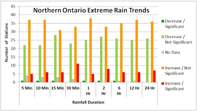
For northern Ontario climate stations there are more increasing than decreasing trends.

Ontario climate change IDF

Ontario climate change rain


Over time, the average maximum rainfall intensity is statistically expected to increase as the sample size increases, without indicating a change in the underlying rainfall characteristic. This is so for all skewed probability distributions as any additional sample values (i.e., annual observations) that fall in the extreme tail push the observed mean higher. To illustrate the skew in observations, the following table excerpt from Environment Canada's IDF table (idf_v2-3_2014_12_21_615_ON_6158355_TORONTO_CITY.txt) shows the positive skew values for 5 minute to 24 hour annual maximum observations from 1940 to 2007:

Ontario storms climate change
Toronto City (station ID 6158355). Positive skew in rainfall distribution for all storm duration. Coefficients of variation of
0.408, 0.355, 0.400, 0.419, 0.393, 0.360, 0.349, 0.318, and 0.306 indicate that sample mean will be biased for small sample sizes, resulting in increased rainfall intensities over time as sample size increases and positive skew observations are added to the sample mean result. Hence mean extreme rainfall will increase without an increase in the underlying rainfall patterns, but instead as a result of the sampling methodology for small sample sets of  rainfall 'population' with a skewed probability density function (i.e., stationary distribution with no underlying climate change related trends in extreme rainfall). 

The following charts show histograms of 5 minute and 24 minute annual maximum observations for Toronto City gauge, illustrating this skew characteristic.


The following charts show how sample size affects the ability of samples observations to approximate the mean of an underlying distribution, and how population skew affects the trend in samples mean. This is from Kirk G. Fleming's article "Yep, We’re Skewed", VOLUME 2/ISSUE 2 CASUALTY ACTUARIAL SOCIETY.


Mr. Fleming writes: "Figure 1 shows three lognormal curves, each with a mean of 1,000 and with varying degrees of skewness. As the skewness increases, the mode or highest point on the distribution is associated with points closer and closer to zero.1 For a lognormal distribution with a coefficient of variation (CV) of 2.0, the most likely value for a sample size of one is relatively close to zero, no matter how big the mean of the distribution. For small samples from this skewed distribution, the most likely value for the sample average will be close to zero.

In order to give a feel for what makes up a small sample size, I simulated random values from a lognormal distribution with a mean 1,000 and varying degrees of skewness. The modes for the sample averages of various sizes are shown in Figure 2 for lognormal distributions with a mean of 1,000 and CVs of 0.5, 1.0, 2.0, 5.0 and 10.0. For individual claim size distributions that have low skewness, the most likely value that we will see from a sample average very quickly approaches the mean of the distribution. Many introductory statistical textbooks give a rule of thumb that infinity begins at a sample size of 30, and for low skewness 30 does seem to be a magic number when we are dealing with the lognormal distribution. However, as the skewness increases, it takes a very big sample size before the most likely value of the sample average approaches the mean of the sampled claim distribution.

For a lognormal distribution with a CV of 10, even at a sample size of 500, the most likely value we would see from the sample average is 85% of the distribution mean. Formal credibility formulas aside, I believe many actuaries would consider 500 homogeneous claims to be a fairly large database.

With a CV of 10 and a sample size of 10,000, the most likely value we would see is still only 96% of the mean of the distribution. A simulation size of 10,000 is not an uncommon size for actuaries doing simulations. Even with this large sample, there is still a downward bias of 4% from the actual average of the distribution."

****

Looking at Toronto rainfall data, assuming a log normal distribution of annual extremes as in Fleming's example, and that the CV is in the range of 0.3 to 0.4, this suggests a sample mean would increase over the first decades of the observations as it approaches the true population distribution, and would stabilize near the true mean after 25 years or so. Accordingly, any short duration climate station data trends would increase over time. The median record length (number of samples) is 24 years, indicating that many stations would have a bias in rainfall intensity trend. The natural, statistical increase in rainfall can be confused with a change in underlying rainfall intensity (e.g., due to climate change), whereas the observed increase in extreme intensity is only a known sampling bias in a skewed rainfall probability distribution.

Rainfall sample mean bias for skewed distribution results in samples means that are less than the underlying population mean. Underestimation bias increases with higher skew distributions.


****

Extreme rainfall trends in Canada (Environment Canada Engineering Climate Datasets):

Static Maps: http://www.cityfloodmap.com/2015/12/severe-storm-trends-canada-rainfall.html
Interactive Map: http://www.cityfloodmap.com/2015/12/canadian-extreme-rainfall-map-climate.html
Table Summaries: http://www.cityfloodmap.com/2015/12/canadian-extreme-rainfall-summary-by.html
Chart and Table: http://www.cityfloodmap.com/2015/12/top-weather-story-in-canada-2015-less.html
Long-term Station Table: http://www.cityfloodmap.com/2015/12/long-term-climate-change-short-term.html
Environment Canada Denies Changes: http://www.cityfloodmap.com/2015/10/bogus-statements-on-storms-in-cbcnewsca.html
Contradicting Insurance Industry Claims: http://www.cityfloodmap.com/2015/12/trends-in-canadian-shortduration.html

Climate Change Ontario - Short Duration Rainfall Trends - Less Severe Southern Storms

Ontario climate changeEnvironment and Climate Change Canada's Engineering Climate Datasets' rainfall trend data have been summarized to show Ontario climate change trends. Data have been screened to show recently active rainfall gauge observations with more reliable, longer term records.

The summary tables below show rainfall intensity trend data for stations in southern Ontario (south of latitude 44 degrees), with over 30 years of record. The majority of trends are not statistically significant, and there are slightly more decreasing rainfall intensity trends than increasing ones. The summary table trends correspond to observed annual maximum recorded rainfall depths over various short durations. Have scientists been muzzled by the federal government from sharing this? Have Ontario scientists and engineers missed the facts that don't support the rationale for cap and trade, Bill 172?

The trend data are available in the version 2.3 dataset (file: idf_v2-3_2014_12_21_trends.txt, in
IDF_Additional_Additionnel_v2.30.zip, available at:
ftp://ftp.tor.ec.gc.ca/Pub/Engineering_Climate_Dataset/IDF/)

Ontario climate change storms
Southern Ontario Rainfall Intensity Trends. Stations below latitude 44 degrees and with a least 30 years of record focus on south and western stations (no tranditional south east municipalities).
Individual cells in the table correspond to trend lines on individual, observed maximum rainfall charts. Below, a table with longer term stations (> 45 years of record) across all Ontario are shown with corresponding charts. For the Ottawa CDA RCS climate station, shortest duration extreme rainfall volumes and intensities are decreasing for 5 minutes to 3 hour durations, corresponding to the 6 left-most, light-green cells in the table, and the top and right 6 trend charts/times series plots. The next 2 light-red cells and bottom left charts show increasing 1 hour and 2 hour intensities. The last cell in the row and bottom chart shows increasing rainfall intensities over 24 hours - this trend is statistically significant at the 5% level, and so that chart includes the "Trend: +" note.

Ontario climate change storms

Rainfall trend data for the Toronto Pearson International Airport gauge data, located in the City of Mississauga, show a mixture of decreasing short and long duration extreme rainfall observations (5 minute, 6 hour, 12 hour, and 24 hour durations). and increasing mid duration observations (10 minute to 2 hour durations), but not statistically significant trends. The "Trend: N" note at the top of all charts here signifies no statistically significant changes in extreme rainfall characteristics.

Ontario climate change rain

The historical rainfall observations for the central Toronto, Toronto City climate station, show decreasing extreme rain for all durations. Trends for 5 minute to 2 hour durations are mild and not statistically significant. Decreasing trends over 6 to 24 hour durations are stronger and are classified by Environment and Climate Change Canada as statistically significant - such charts include the "Trend: -" note.

Ontario climate change flooding
Overall with the Southern Ontario long term, recent observations, more statistically significant decreasing rainfall intensities have been recorded (8 data points), than increasing intensities (4 data points). The statistically significant decreasing extreme rain data are clustered across storm durations in Toronto and Winsdor.

The only stations with no decreasing rainfall trends are Bowmanville and Oshawa, and the only ones with no increasing rainfall trends are Toronto, Windsor and Hamilton.

The table below shows Ontario extreme rainfall trends for all stations, including inactive ones and those with short records. Overall, there are no significant trends for over 93% of data points, with about 5% of data showing statistically significant increases and 2% showing decreases.

Ontario climate change storms

"Northern" Ontario stations show a greater increase in intensity than southern ones. The table below is similar to the first table, and includes more reliable long term record, recently active stations. Some traditional central and eastern Ontario stations above 44 degrees are included in this definition. Decreasing rainfall trends appear prevalent in the central and eastern stations spanning between -Kingston-Brockville-Cornwall-Kemptville-Ottawa. Increasing rainfall trends are more prevalent at the far north stations.
Northern Ontario climate change
"Northern" Ontario extreme rainfall trends. Includes central and eastern Ontario stations below 44 degrees latitude.

Extreme rainfall trends in Canada (Environment Canada Engineering Climate Datasets):

Static Maps: http://www.cityfloodmap.com/2015/12/severe-storm-trends-canada-rainfall.html
Interactive Map: http://www.cityfloodmap.com/2015/12/canadian-extreme-rainfall-map-climate.html
Table Summaries: http://www.cityfloodmap.com/2015/12/canadian-extreme-rainfall-summary-by.html
Chart and Table: http://www.cityfloodmap.com/2015/12/top-weather-story-in-canada-2015-less.html
Long-term Station Table: http://www.cityfloodmap.com/2015/12/long-term-climate-change-short-term.html
Environment Canada Denies Changes: http://www.cityfloodmap.com/2015/10/bogus-statements-on-storms-in-cbcnewsca.html
Contradicting Insurance Industry Claims: http://www.cityfloodmap.com/2015/12/trends-in-canadian-shortduration.html


Review - The Economic Impacts of The Weather Effects of Climate Chance on Communities - Dilettantism in Flood Depth Estimation

Mississauga climate change
Mississauga climate change. Just playing around with rain  ...
ignoring the sciences of hydrology and practice of hydraulic
engineering with oversimplified analysis and unreliable results.
A new report for Insurance Bureau of Canada by Team Green Analytics (Green Analytics Corp. & Ontario Centre for Climate Impacts and Adaptation Resources) reviews weather effects of climate change including flooding in an urban area. It is entitled The Economic Impacts of The Weather Effects of Climate Chance on Communities. It can be downloaded here.

Mississauga is used a the test case for storm damages, specifically river flood plain damages. The analysis estimates expected annual damages today and in the future under various climate change scenarios. The Community Impact Analysis Tool (CIAT-Flood) was developed to allow other communities to apply the analysis - the spreadsheets "within which the calculations and data are stored to estimate direct and secondary expected annual damages (EAD) for each of the climate related extreme events of relevance to this project."

A review of the methodology suggests that results should be viewed with caution due to several inappropriate assumptions that have been made - the absolute value of damages will be overestimated and incremental climate change impacts will be overestimated.

Mississauga climate change
Is runoff volume or rate proportional to average rainfall
intensity across all durations as assumed in this study? No.
Half the rain produces less than half the runoff for pervious
surfaces as shown in the standard SCS Curve Number chart.
In general, assumptions regarding the extrapolation of flood depths from known 100 year values to lower return period values on the basis of the ratio of average rainfall intensities is not considered valid. The study's approach shown in the yellow highlight text below would overestimate the depths and damages for lower return periods where there is actually no flooding (e.g., sometimes even 50 year and below). This would overestimate the absolute value of the baseline and the future climate scenario damages. Typically 5 year rainfall intensities are half of 100 year values, meaning half depths would have been assigned - in reality, 5 year flood flows rarely leave a channel/valley to cause flood plain damages because:

  1. non-linearity between rainfall and the runoff volumes affecting peak flows means half the rain results in less than half the flow (see standard SCS runoff-rainfall relationships above - a 5 year storm with say 50 mm or 2 inches of rain has very little runoff from the pervious surfaces in a watershed),
  2. no-one builds within a 5-10 year flood plain (except maybe ancillary structure / sheds).
To illustrate item 2 above, the table below shows how flood depths vary by return period in Mississauga's Cooksville Creek which has over 100 properties in its 100 year floodplain. As shown, reaches of the creek typically have flow capacity limitations and flooding for the 100 year event (as indicated by road and rail crossing overtopping) however they do not have constraints for all lower return period events. Of 26 crossings, only 4 are overtopped for the 2 year event. Of 12 crossings that are overtopped for the 100 year event, only 7 are overtopped for the 10 year event. The Team Green Analytics report assigns flood depths and damages to the these lower return period events where there is no flooding, where design flows stay in the channel and the major drainage system is not overtopped. Their analysis improperly, and inadequately applies hydrologic and hydraulic engineering principles.

Cooksville Creek flood master study class EA in Mississauga shows river drainage system

Mississauga climate change
Is flood depth proportional to average rainfall intensity across all durations
in an IDF curve as assumed in this study? No - it is not. That assumption
skips over the science of hydrology and the practice of hydraulic engineering.

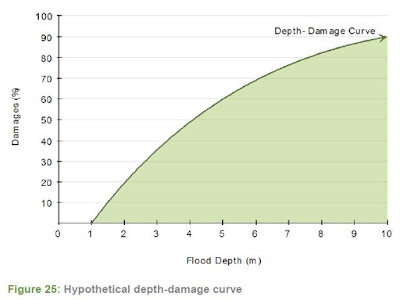
As damages are nonlinear as well, as shown by the damage depth curve at right, relatively high low return period damages would be estimated. Yet, actual river floodplain damages are nil for smaller return period year events - overall, frequent flood floods stay in the channel as demonstrated in the rail/road overtopping table.
Mississauga climate change
Is flood depth proportional to average rainfall rate over all durations
in and IDF curve as assumed in this study, or are flood elevations or
depths in an urban watercourse system proportional to flow?
No - flows would increase less than rainfall (or in the case of this study
that factored downward from 100 year would decrease more than 
the rainfall proportion [less depth], and elevations would increase less
than the increase in flow (or in this case decrease more than the 
rainfall proportion [less depth]). Flood elevations are non-linear
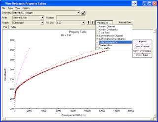
as shown in the above depth-flow curve. Climate change increased in
intensity would have muted effects on flow, flood elevation and
flood damages, contrary to the study results.
Also, the approach used to factor flood depths to changing climate midpoints is not considered valid. Shown in the study's approach in the  orange highlight below, depths are assumed to increase with the average rain intensity change across all durations. While it may be appropriate to conservatively approximate increases in flow with that of intensity in a completely urban watershed, it is certainly not appropriate to do so for flood stage, or hence, flood depth - this assumption ignores the basic non-linearities of river rating curves. Hydraulic systems become more efficient at conveying flows at high flow rates as the hydraulic radius of a cross section increase with depth (relative hydraulic roughness decreases). Therefore the Green Team Analytics analysis inappropriately applies common hydraulic engineering principles. In fact fundamental principles are ignored.

The example in HEC-RAS at right shows how depth increases only marginally as flow increases. This would result in lower flood depths and incremental flood damages for future climate scenarios compared to the baseline climate. As roadways would generally be over-topped during extreme events (e.g., see Cooksville Creek example table above), resulting in "weir flow" conditions, further non-linearities are expected with the flow regime, dampening depth increases even more. Undergraduate fluid mechanics and hydraulic engineering classes all learn weir flow capacity increases with a 1.5 exponent power function relative to depth, not linearly with a 1.0 exponent. The Green Team Analytics analysis ignores basic hydraulic engineering principles.

To check the analysis issues noted above, real flood plain hydraulic model results with real flood depths for multiple return period events below the 100 year event were reviewed. Data are for a GTA municipality, screened for residential properties. These data are derived from engineered floodlines that properly consider urban hydrology and floodplain hydraulics. Real data shows diminishing counts for properties flooded for smaller return period events, accurately reflecting common hydrology trends in watersheds and hydraulics in river systems. The real depth of flooding decreases to zero for small return period events. Using property count and depth as an indicator of flood damages, using rain frequency to estimate flood depths over estimates the absolute flood risk by 55%. Given non-linearity in flood damage curves, absolute flood damages would be overestimated by even more (> 55%). The Green Team Analytics report does not consider fundamental hydrology and hydraulics to estimate flood damages, and as a result incorrectly overestimates small storm damages.

Mississauga climate change
Comparing Mississauga Flood Damage Estimate Approach to Using Real Flood Data:
using rain intensity and no hydrology, or hydraulics, overestimates flood damages compared to using real data.

The report "Evaluating flood damages:  guidance and recommendations on principles and methods" (January 2007) by FLOODSite describes critical data needed for flood damage estimation. FLOODsite is co-funded by the European Community Sixth Framework Programme for European Research and Technological Development (2002-2006). From the report (page 17-18):

"...it is on the critical parameters upon which attention should be focused in seeking to improve the estimates of the parameters. It is also on these parameters upon which risk management should be focused. In general, it is those benefits and costs which occur early in the life of the intervention strategy and/or occur frequently which are likely to be critical. These include:
• Capital costs
• Operation and Maintenance costs
• Flood levels as estimated from ground levels and water levels
• Damages from frequent floods
• Land uses at low levels including below ground land uses"

The report The Economic Impacts of The Weather Effects of Climate Chance on Communities does not address bullet items 3 or 4 with any focus: no estimate of flood levels (i.e., depths) using water levels and ground levels are used (depths were estimated from rainfall); no damages from frequent floods are calculated (depths and damages were estimated based on rainfall with no flood hydrology considerations, nor flood hydraulics considerations).

Here are the Green Team Analytics study's flood damage assumptions:

Page 163 Appendix B. Key Data and Assumptions – Direct Impact Estimates in Mississauga:

Spatially explicit GIS flood extent data for the historical 100 year return period was available167 and was used in this analysis but no additional flood extent data existed for other return periods or climate change scenarios. Therefore, the relative changes in IDP based on data from the IDF_CC Tool was used as a proxy to alter the flood depths across the existing buildings within the historical 100 year return period flood extent. This allowed for an estimate of the flood extent across all above return periods both for the historic time period (baseline climate change scenario) and the future time periods while accounting for climate change (moderate and high climate change scenarios).

Firstly, the return period values of the IDF curves for three time periods were utilized: baseline (1960-1990), and two future periods under a climate change scenario (2015-2045 and 2035-2065). The rainfall intensity was provided for several durations (5 mins, 10 mins, 15 mins, 30 mins, 1 hr, 2 hr, 6 hr, 12 hr and 24 hr) measured in mm/hr, and across each return period (2yrs, 5yrs, 10yrs, 25yrs, 50yrs and 100yrs). The average relative rainfall intensity across all durations was calculated between the baseline period (1960-1990) and the two future time periods (2015-2045 and 2035-2065) under the climate change scenario. These relative results provided a proxy to estimate the relative change in flood depth across return periods between the baseline time period (recent historic climate) and the two future time periods under a changing climate (midpoints: 2035 and 2050). Additionally, the average relative rainfall intensity across the durations was calculated between the baseline 100 year return period values and the other baseline return periods considered in this analysis (2yrs, 5yrs, 10yr, 50yrs). Since data was only available for the 100 year historic flood extent, the flood extent for the other baseline return periods were calculated by multiplying this relative change in rainfall intensity as a simple proxy to estimate the flood depths at each building across all of other return periods considered. Once the baseline flood depths versus return periods were calculated for the baseline historic climate change scenario, then the flood depths versus return periods were calculated for the future time periods assuming the given future climate change scenario using the relative change in rainfall intensity as a proxy.

The report estimates that by 2020 expected annual damage (EAD) attributed to climate change increases by 2.4% (moderate climate change) to 2.5% (high climate change) relative to the corresponding baseline scenario. And by 2040, EAD increases by 6% (high climate change) to 13% (moderate climate change) relative to the baseline. Given issues with the assumed flood depth - rainfall intensity relationship, EAD values would likely increase by a lower amount (say less than 5% for high climate change and less than 10% for moderate climate change) if a more appropriate non-linear rainfall-runoff-design flow relationship, and more appropriate non-linear design flow-flood stage elevation (flood depth) relationship were used.

The study analysis related to river flooding and the CIAT-Flood Tool are intended to quantify flood damages to guide investments in adaptation measures. The report indicates that the analysis does so at the community-level:

"Thus, to help identify areas where adaptation investments may be justified, there is a need to quantify, at a community-specific level, the expected impacts to communities from such events. Within this context, the current project focuses on quantifying the impacts of climate-related extreme events at the community scale."

Therefore, the report and the tool coarsely apply (or skip over) engineering principles and makes recommendations on flood impacts to guide adaptation investments. The report does not recognize that engineering data or models are need to complete the analysis. On input data, engineering or public works departments are not identified as a key data source:

"Data requirements: The data required to conduct an impact analysis of climate-related extreme
events is dispersed across numerous municipal departments and organizations, which means that
the completion of an analysis such as this necessarily requires a minimum degree of engagement
from many departments (such as parks, forestry, water, power, planning, economic development and
geographic information systems) and organizations (conservation authorities and power utilities)."

Public works departments, where traditionally engineering is practiced at municipalities, are noted as users of the analysis tool.

"6.2 Target Audience
The CIAT is primarily designed to be used by municipal staff across a range of departments including, but not limited to planning, economic development, environment, parks, forestry, finance, risk management, and transportation and public works departments. Water and sewer services departments and local electrical distribution utility providers may also find the tool useful or be engaged through data sharing."

Overall, the role of engineering analysis is limited. Input from conservation authorities may contain usually engineering data (watershed hydrology or river hydraulics), but this is has not been appropriately used in the report or the tool. Expected annual damages should not have been estimated by extrapolating 100-year damages to more frequent event damages (where there are often no damages for small events), and changes in flood depth that drive damages should not have been estimated based on changes in rainfall intensity (using multiplication as a 'simple proxy' for proper engineering analysis).

***

Vit Klemes RIP would be thoroughly annoyed at the efforts put toward the flood damage analysis in the report above. I remember he introduced concepts of non-linearity in flood risk hydraulics in an undergraduate civil engineering class guest lecture at U of T (Galbraith Room 305 I think?). It's time to brush up on some of his classics like Dilettantism in hydrology: transition or destiny?. Or if you have not read it please see his key note address to International Interdisciplinary Conference on Predictions for Hydrology, Ecology, and Water Resources Management: Using Data and Models to Benefit Society, entitled Political Pressures in Water Resources Management. Do they influence predictions? This graphic is from the presentation:
Mississauaga climate change
What were the political priorities to generate Mississauga flood damage estimates under climate change vs. logical priorities. It does not appear that any hydrologic or hydraulic sciences were involved in the report for IBC despite the fundamental need to estimate changes in flood flow, or flood depth as a result of climate change IDF shifts.

In his address Klemes notes:

"[P]olitical pressures often set the agenda for what is to be (or not to be) predicted, and sometimes even try to impose the prediction result thus transforming prediction into prescription."

It is possible that Team Green Analytics was working towards a prescribed result, or at least a plausible result, and accepted the prescribed prediction, shunning the Kahneman System 2 thinking that is required for the complex analysis task. ... or the budget was tight?

Like in his key note address where Vit relates a story from his early career in Czechosolvakia "around 9 o’clock, my boss walked into my office and said 'Vít, by quarter to eleven I need the cost for the Teplice [dam] project' ”, Team Green Analytics had to get a result within the constraints they were given.

Vit related his dilemma : What can one do about an impossible request like that? The command of the professional ethics is clear: Refuse to cooperate, period! But in the 1950s in the communist Czechoslovakia where people were disappearing without trace? Where the gallows, worn out by the recent “liquidation of the enemies of the people”, were being diligently repaired; where a shade of hesitation could mean “sabotaging socialism”, be sent to the mines to “regain the confidence of the working class”, or at best lose the job and be black-listed for any job except window washing or street sweeping? With two kids and the predictable firing and black-listing of my wife?

We'll never know how/if Team Green Analytics was backed into a corner like Vit to produce an impossible result for their report. In the end Vit did what he had to do:

I made my choice: by quarter to eleven I gave my boss the figure – 713 million Czech crowns. This
figure has been haunting me ever since and I made a resolution NEVER AGAIN!

And so they did what they had to do to get this impossible result. The absolute values are too high (improper extrapolation of flood depths by rain intensities to storm with no flooding) and the incremental 2020 and 2040 damages increases are too high (ignored non-linearities in hydrologic transformation of rain to runoff and flow to flood elevation/depth) :

Mississsauga climate change
Flood damages with climate change are overestimated due to non-linearity between rainfall intensity and runoff, and runoff and flood depth. Hydrologic and hydraulic principles have been ignored in the analysis in favour of factoring of results by expected rainfall intensity changes.

Is one month of rain in one day rare? Is weather reporting in Canada accurate?

It is common to see headlines after a damaging storm state that "we had a month of rain in one day", and consider that a plausible cause of the incident. But is this misleading - is comparing a storm to a typically dry summer month meaningful at all? Are drainage systems designed to handle only an average day's rain, or something more extreme? The truth is, most drainage systems in Ontario are designed to handle well over a month of summer month rain in a day.

Examples of the "one month in a day" reporting can be seen after the record daily rainfall July 8, 2013 in Mississauga.

TheStar.Com reported after the incident that stranded customers were offered $100 as compensation and the GO Transit vice-president for customer service said "It is an exceptional gesture for an unprecedented circumstance." She added “That was a night of firsts for us: The first time we had a month of rain in one night ...".

The National Post weighed in making comparisons to rain on the particular calendar date "Before Monday, the highest rainfall ever experienced in Toronto for July 8 was 29.2 mm set in 2008 — a record that was more than tripled". This refers to the 126 mm of rainfall recorded at the Pearson International Airport climate station in Mississauga (not Toronto). It should be stated clearly that no drainage system in Canada is designed for the rainfall expected on a particular calendar date - the reason is that extreme rain can occur on any date and systems must be designed for all calendar dates expected during the service life of the infrastructure. So the National Post observation is meaningless when assessing the severity of the July 8, 2013 storm against the capacity of drainage systems.

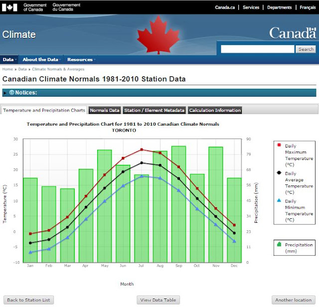
Back to GO Transit and Metrolinx's assertion that a month of rain in one night is unprecedented. To assess this we can refer to Environment Canada's published "climate normals" including average monthly rainfall amounts. As expected those are low in the summer.  For example, in Toronto where the GO Train was stranded the average rainfall for July is 63.9 mm, as shown below or at this link:

climate change Toronto

The rainfall statistics for Toronto below show that even a moderate frequency "10 year storm", with 67.6 mm of rain over a 24 hour duration, exceeds the monthly average by 6% (see bottom row, fourth column).  So it is not unusual that a moderate storm exceeds the average monthly total - there is actually a 41% chance we will have at least one 10 year storm every five years (Probability = 1 - [1 - 1/10]^5 = 1 - 0.9^5 = 0.41, or 41%).

climate change Toronto
Table 2a Return Period Rainfall Amounts (mm) in file: idf_v2-3_2014_12_21_615_ON_6158355_TORONTO_CITY.txt
Version 2.3 data set for Ontario file: IDF_v2.30_2014_12_21_ON.zip
Consider that the minimum standard for river flood hazard assessment in Ontario is the greater of the 100 year storm or the more extreme historical regional storm. Most municipalities have a minimum 100 year level of service for urban drainage systems. That means new drainage systems are designed for about 94.7 mm of rain in 24 hours - 48% more than the average monthly total.

So is more than a month of rain in a day unprecedented? No.The graph below shows that the July monthly total rainfall at Pearson Airport was exceeded 6 times from 1950 to 2015, so once every 10-11 years, The Richmond Hill GO Train service started in 1978 so the monthly total was exceeded twice during years of operation before the July 8, 2013 incident - specifically in 1980 119.9 mm was recorded, exceeding the monthly total by 58%, and then again in 1995 78.8 mm was recorded, exceeding the monthly total by 4%. Exceeding monthly rainfall totals on a given day as a result of a moderate storm is not unusual based on historical records. Metrolinx was uninformed to suggest that July 8, 2013 was unprecedented for the operation of the Richmond Hill line. In fact, an earlier post shows that the maximum flood level recorded in 2013 was not on July 8, but on May 29, 2013 with 10 cubic metres per second more flow and 20 centimetres deeper flooding on the Don River observed.

climate change Mississauga
The average July rainfall total is exceeded on a single day every 10-11 years, including several times since the operations of the Metrolinx Richmond Hill GO Train service was started in 1978. Exceeding the monthly rainfall total is not rare from a drainage design perspective as summer months are typically dry and moderate design storms have greater rainfall.
The resulting flow rates in the Don River on July 8, 2013 were not rare or unprecedented compared to design flows shown on the following chart:

climate change Toronto

Weather reporting in Canada needs to be improved to provide accurate assessments of severity and risk based on relevant frequency and design data and not erroneous data comparisons.

Its time to overcome heuristic biases in reporting and start thinking carefully and slowly on important weather reporting and weather related policies in Ontario. 

IDF Curve Update for Climate Change Impacts - Rational Method and Design Storm Considerations

climate change Canada
Feels like a 10-year Chicago rain distribution ...
Intensity-duration-frequency (IDF) curves describe rainfall intensities used for drainage design. Sometimes the data are used directly as part of the Rational Method to calculate peak runoff rates at an instant in time. But such a simple application is rare as part of modern flood risk assessment and storm drainage remediation - in those more sophisticated applications, a temporal distribution of rainfall intensities is required to simulate the infiltration, runoff, routing, and storage processes in rural watersheds or urban drainage networks.

The temporal distribution of rainfall - also called a hyetograph or design storm - is essential for deriving a times-series of flow (aka a hydrograph) or flood water levels in systems. So simple Rational Method calculations using IDF curves are to photos what robust simulations with hyetographs are to videos.

Significant emphasis has been placed on updating IDF curves as a means of assessing climate change impacts to drainage systems. But less emphasis has been placed on updating the more critical hyetographs used in flood risk assessment and remediation. Why is that important? Because hydrologists can take the same underlying IDF data and turn it into either very conservative or unconservative design storms. That's right. While there are best practices, there are no rules for selecting the pattern, duration or peak intensity of design storms.

To show this, below are hyetographs used for flood risk assessment and remediation design in a Greater Toronto Area (GTA) municipality. All of these are "100 year design storms", meaning they theoretically have a probability of 1% of being exceeded in any year.


All have been derived by respected professionals, university professors, consultants and watershed managers at Ontario's best-funded and most advanced conservation authority. What do you notice? Different durations, vastly different peak intensities. Some design storms have been 'flattened out', averaging the peak rainfall intensity - the Rouge River floodplain design storm averages rainfall over the peak hour which essentially misses the critical short duration intensities that govern peak flood flows in flashy urban catchments. As shown below, flattening out hyetographs can turn a "100 year" storm into less than a 15 year storm for small, flashy watersheds.

IDF curve climate change
Design hyetographs can underestimate IDF data (Rouge Watershed "100 year" storm intensities are less than 15 year storm frequency for small flashy urban watersheds with times of concentration of 1 hour or less, based on Toronto IDF data), or can be conservative (Markham design hyetograph exceeds 100 year frequency for small watersheds).

Question: What is the result of using different 100 year hyetographs?
Answer: Vastly different runoff characteristics for any given watershed or catchment of course.

Different 100-year design storms mean different hydrographs with different peak flows and different maximum flood levels in watercourses, storage ponds ... and potentially back-up in basements. In fact the 'low-energy' 100-year Rouge River 12 hour storm (aka the Jeb Bush) results in a peak flow similar to a 2-year storm using the 3 hour city design storm. In that storm the peak 5 minute intensity, peak 10 minute intensity, peak 15 minute intensity, peak 30 minute intensity values are lost / averaged out. As a result, in any simulation the calculated peak flows and peak flood levels are attenuated, underestimating flood risks and damage potential.

You should ask: what is the net impact of updating IDF curves, e.g., increasing intensities by say 20% to reflect projected climate change impacts or tweaking intensities with other the best-fit extreme value probability curve-fitting, if you then average out those intensities in the hyetograph, cutting peak IDF intensities by 85% in the design storm, relative to raw underlying data? In the case of the Rouge River watershed storm, the net impact of increasing IDF values by 20% for climate change and then decreasing them by 85% is a net reduction in peak rainfall design intensity of 80%.

It is likely that flood risks in urban watercourses are underestimated where attenuated hyetographs are used. Similarly, the flood elevations at storm sewer outfalls (aka 'tailwater' in the storm sewer network) that could indicate back-up risks for upstream connected basements are also understimated.

Below is a comparison of Toronto IDF statistics from observed rainfall records and the intrinsic intensity-duration characteristics in synthetic design storms (aka hyetographs):


Obviously the five various 100 year design storms do not measure up to the underlying statistics, falling short over durations of 5 minutes to 2 hours - critical durations for urban drainage design.

climate change CanadaDesigning New Drainage Systems:

Because only local storm sewers are designed directly with IDF data and new system already has a major overland relief system in place, the value in updating IDF curves for new subdivision design is limited.

Upgrading Old Drainage Systems:

Flood remediation studies rely on hyetographs. Typically systems are upgraded from 2-year or 5-year storm capacity to 100-year storm capacity, meaning a 100% to 150% increase. This gives a good benefit/cost as the most frequent flood events are prevented or mitigated, and therefore the most damages are deferred. Upgrading an old system further, considering possible climate change impacts to IDF curves that make design storms greater will yield a lower benefit/cost. This is so because the incremental increase in storm system capacity will not be used as frequently, and the incremental cost will be greater (as pipe sizes becomes greater, the sewer profile becomes deeper and in conflict with other services, subsurface utility relocations and restorations can also escalate - at greater depths, construction methods may become more costly (e.g., slide rails vs. trench boxes) to ensure worker safety, and dewatering (necessary for soil stability and construction safety) at the greater depths can add significant extras to project costs) - at greater depths, extensive dewatering can also introduce the potential for settlement at adjacent properties and damages - even if there are no damages, monitoring to document no settlement or damages adds to project implementation costs).

Pick a robust hyetograph!

Not Upgrading Old Systems?:

You should consider upgrading. Although observed extreme rainfall is not increasing in southern Ontario, and statistical trends in other parts of Canada are weak, runoff is increasing and overland flow paths are being compromised in many urban areas. Since we cannot restore lost rivers that used to take the flow, upgrading drainage systems is the most practical thing.

***

Good old analysis that has stood the test of time:

Back in 1674 Pierre Parrault published “De l’origine des fontaines” which quantitatively related rainfall to streamflow in the watershed it falls in. It took almost 200 years for others to also conclude that the ratio of runoff to rainfall could be approximated as a coefficient (i.e., a fraction of the rain turns into runoff). And then a refinement in 1851 that has stood the test of time - Thomas Mulvaney presented to the Irish Institution of Civil Engineers that peak runoff rates are related to the response time of the watershed. And so for the last 165 years engineers have been using the rainfall intensity (the "I" in IDF) over the response time duration (the "D" in IDF) of a watershed to determine peak runoff flow rates by applying the Rational Method.

What the "F" you say? "F" is for frequency, or the probability of achieving an intensity based on a probability distribution. Such distributions are calculated based on historical intensity observations that are fit to theoretical distributions.


Toronto Climate Change Extreme Rainfall Trends - IDF Curve Updates

Toronto climate change
Toronto: temperature up - rainfall down
Toronto climate change trends are clear when it comes to temperature - yes, going up. But for rainfall, Environment Canada's Intensity-Duration-Frequency (IDF) data show decreasing trends for short duration extreme and common rainfall events. Short duration storm intensities are used in hydrological analysis and design of urban drainage systems and can be an indicator predicted climate change impacts. Extreme storm intensities represent urban flood risks - fortunately, so far, there are no increases in extreme Toronto rainfall according to official datasets.

Toronto climate changeDowntown Toronto shows the most consistent decrease in observed rainfall intensity and corresponding decrease in design rainfall intensity. These design intensities are based on extreme value statistics as derived by Environment Canada using the raw weather observations at the climate station.

The tables at right show intensities for "Toronto City" Climate Station ID 6158355 (aka "Toronto" 6158350) for three recent Environment Canada IDF curve updates:

  1. Up to 1990 (47 years of record)
  2. Up to 2003 (57 years of record)
  3. Up to 2007 (61 years of record)

Design rainfall intensities are shown for short durations of 5 minutes, 15 minutes and 1 hour in the three tables.


Changes in rainfall intensity are also shown up to 2003 and up to 2007 in the right two columns. All design intensities have decreased for all durations and for all return periods from 2 to 100 years (i.e., common storms to rare storms). Is the Ontario government muzzling scientist and engineers from sharing this, to justify cap and trade and Bill 172 to fight flooding through climate change mitigation? That would seem misguided, not evidence-based as storm intensity is not increasing.

The most extreme (rare) "100 year" rainfall intensities that have a 1% chance every year have decreased between 3.7% and 5.5% for 1 hour to 5 minute durations, respectively. The more common "2 year" intensities with a 50% chance every year have decreased as well, dropping 2.5% to 4.1%. 

A similar climate change in severe weather is observed at the Pearson International Airport climate station in Mississauga, Ontario. The Environment Canada label for the this station ID 6158733 is "TORONTO INTL A", or "TORONTO LESTER B. PEARSO ONT", which inaccurately identifies Toronto as the municipality where the gauge is located.

The tables at right show intensities for four recent Environment Canada IDF curve updates in Mississauga:
Mississauga climate change

  1. Up to 1990 (38 years of record)
  2. Up to 2003 (51 years of record)
  3. Up to 2007 (54 years of record)
  4. Up to 2013 (60 years of record)
Changes in rainfall intensity are also shown from 1990 up to 2003, 2007 and 2013 in the right three columns. Design intensities have decreased for shorter durations (5 and 15 minutes) for all return periods from 2 to 100 years (i.e., common storms to rare storms).

For longer duration intensities, the trend is mixed with "2 year" common intensities decreasing 4.1% and rare "100 year" intensities increasing 10.9%. The increase reflects the fact that a record rainfall was recorded in the last year of the record (July 8, 2013). Subsequent years have shown below average extremes - in 2014 and 2015 the maximum daily rainfall totals were only 27.6 mm and 37.4 mm, respectively, both less than the average "2 year" value of 47.6 mm. These recent trends would result in a return to lower design intensity values. The chart below shows the decreasing trend in daily rainfall totals up to 2013 and up to 2015. The downward trend in 24 hour maximum rainfall is stronger when 2014 and 2015 are included (dashed blue line). Yet, even if the recent lower daily rainfall totals are excluded, the trend is downward (dashed red line).


Looking at longer durations, 12 and 24 hours, the overall Mississauga Pearson trends are flat or lower as well since 1990:


Mississauga climate change IDF

What do the Toronto and Mississauga "Toronto Pearson" IDF trends mean for drainage design? Hopefully nothing. Although downtown Toronto trends have been steadily decreasing, the most recent 2013 storm is not included and could moderate the downward trend in severe rainfall statistics. Although Mississauga Pearson has some increasing intensities, this is skewed by the timing of the most recent record and absence of even more recent below average data points. And although some Mississauga intensities increase (above 5 year, 1 hour data), short duration values remain below downtown Toronto values in an absolute sense, meaning the Mississauga values are just 'catching up' to the historically higher Toronto ones. To illustrate this, up to 1990 the 5 minute Toronto 100 year design intensity was 21% above the corresponding Pearson value. In 2007, that Toronto statistic was still 20% higher.

Given decreasing or as yet inconclusive or mixed IDF trends, municipalities relying on the long term Toronto and Mississauga Pearson rainfall statistics should focus on other elements of drainage design besides IDF curve updates to reduce urban flood risk. These elements include review of runoff coefficients that increase with intensification and infill development or denser urban design, and return period factors to increase conservatism when IDF values are used in rational method design. Design hyetographs based on IDF values should also be reviewed for conservatism, especially how mass curves are used to distribute IDF rainfall totals over design storm periods - preservation of peak rainfall intensities within the hyetograph pattern would have a significant influence on peak runoff rates for flashy urban catchments.

*****

“It's tough to make predictions, especially about the future.” ― Yogi Berra

*****
Update to 2016 Pearson Airport Daily Maximum Rainfall Totals: earlier decreasing trend continues in 2016:


*****
A comparison of IDF values in southern Ontario between the pre-version 1 1990 datasets and the current version 2.3 datasets shows an overall decrease in frequent rainfall and essentially no change in infrequent rainfall - here are a few results from that post:

Ontario Extreme Rainfall Trends IDF Curves Climate Adaptation

Ontario Extreme Rainfall Trends

IDF values should increase over time as sample bias is reduced with longer data sets that better characterize extreme events in the population. Samples (aka observations) from skewed populations like rainfall require long records with many observations for these extremes to be reflected in the IDF statistics - a previous post explores this in context of the variability we see in rainfall observations. The IDF review above considers climate station records with 30 years of observations or more in which sample bias is expected to be low (see Toronto example in previous post).